IMAGES TAKEN NEAR TO
Hanwood Heights, BELFAST, BT16 1XU
Introduction
This page details the photographs taken nearby to Hanwood Heights, BT16 1XU by members of the Geograph project.
The Geograph project started in 2005 with the aim of publishing, organising and preserving representative images for every square kilometre of Great Britain, Ireland and the Isle of Man.

There are currently over 7.5m images from over14,400 individuals and you can help contribute to the project by visiting https://www.geograph.org.uk
Image Map
Images are licensed for reuse under creativecommons.org/licenses/by-sa/2.0
Notes
- Clicking on the map will re-center to the selected point.
- The higher the marker number, the further away the image location is from the centre of the postcode.
Image Listing (40 Images Found)
Images are licensed for reuse under creativecommons.org/licenses/by-sa/2.0
Image
Details
Distance
1
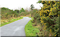
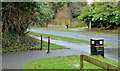
The Comber Greenway, Dundonald (7)
Much of the Greenway between the Eastlink Road and the Beersbridge Road is in deep cutting. This part, looking back to here Image, is in a shallow cutting behind Moatview Park. Some early whin flowers are now starting to appear.
Image: © Albert Bridge
Taken: 29 Jan 2014
0.06 miles
2
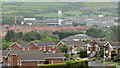
Hanwood Heights, Dundonald
Suburban houses, on the northern side of the Old Dundonald Road, seen from a height on the Ballyhanwood Road Image This water tower Image can be seen in the background.
Image: © Albert Bridge
Taken: 26 Jun 2012
0.08 miles
3
The Comber Greenway, Dundonald (6)
The Greenway, close to Moatview Park, looking down to the Eastlink Road and here Image This short stretch is one of the few parts not built on the course of the old railway.
Image: © Albert Bridge
Taken: 29 Jan 2014
0.09 miles
4
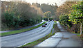
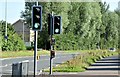
The East Link Road, Dundonald
The East link Road connects the Upper Newtownards Road to the Comber Road and the Old Dundonald Road (upper middle). This view is from close to Leatham Square with the entrance to the Comber Greenway at middle right (beside the litter bin).
Image: © Albert Bridge
Taken: 8 Jan 2014
0.09 miles
5
The Comber Greenway, Dundonald (5)
The Comber Greenway (the course of the old railway) crossing the Eastlink Road. The section to Belfast Image is in the background. The next stretch (foreground) makes a short deviation before continuing to the Comber Road and the site of Dundonald station Image
Image: © Albert Bridge
Taken: 29 Jan 2014
0.10 miles
6
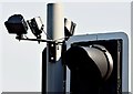
"Toucan" crossing, Dundonald - August 2015 (2)
See Image The infra-red cameras (top left) used to detect the presence of people and adjust the red light/green man sequence accordingly.
Image: © Albert Bridge
Taken: 13 Aug 2015
0.10 miles
7
"Toucan" crossing, Dundonald - August 2015 (1)
See Image A “toucan” crossing, commissioned in January 2014, on the East Link Road, at the Comber Greenway Image The toucan is a wider version of the puffin. It allows pedestrians and cyclists to cross at the same time. Infra-red cameras, mounted on the lights, detect the presence of people and adjust the red light/green man sequence accordingly. Image shows the cameras.
Image: © Albert Bridge
Taken: 13 Aug 2015
0.10 miles
8
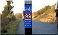
National Cycle Network sign, Dundonald
See Image Route 99 (looking towards Knock), along the Comber Greenway, at the East Link Road, Dundonald.
Image: © Albert Bridge
Taken: 23 Jan 2010
0.10 miles
9
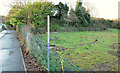
Vacant site, Dundonald
Part of a vacant site on the East Link Road, beside the Comber Greenway (background).
Image: © Albert Bridge
Taken: 8 Jan 2014
0.10 miles
10
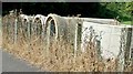
Concrete pipes, Dundonald (August 2015)
Long-abandoned concrete pipes, some of which are now sprouting weeds, on this site Image (January 2014) beside the East Link Road.
Image: © Albert Bridge
Taken: 13 Aug 2015
0.10 miles