IMAGES TAKEN NEAR TO
St. Johns Wood Park, BELFAST, BT16 1RS
Introduction
This page details the photographs taken nearby to St. Johns Wood Park, BT16 1RS by members of the Geograph project.
The Geograph project started in 2005 with the aim of publishing, organising and preserving representative images for every square kilometre of Great Britain, Ireland and the Isle of Man.

There are currently over 7.5m images from over14,400 individuals and you can help contribute to the project by visiting https://www.geograph.org.uk
Image Map
Images are licensed for reuse under creativecommons.org/licenses/by-sa/2.0
Notes
- Clicking on the map will re-center to the selected point.
- The higher the marker number, the further away the image location is from the centre of the postcode.
Image Listing (136 Images Found)
Images are licensed for reuse under creativecommons.org/licenses/by-sa/2.0
Image
Details
Distance
1
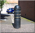
Milepost, Dundonald
Milepost on the Upper Newtownards Road, Dundonald, at the corner with St Johns Wood Park. It records that the distances to Belfast and Newtownards are both 4 miles from here; Donaghadee is 10 miles away. See also Image
Image: © Rossographer
Taken: 30 Aug 2010
0.02 miles
2
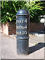
Milepost, Dundonald
Milepost on the Upper Newtownards Road, Dundonald, at the corner with St Johns Wood Park. It records that the distances to Belfast and Newtownards are both 4 miles from here; Donaghadee is 10 miles away. See also Image
Image: © Rossographer
Taken: 30 Aug 2010
0.02 miles
3
Apartment block on Ballyregan Road, Dundonald
Image: © Eric Jones
Taken: 21 May 2012
0.04 miles
4
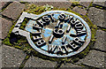
Belfast Water Works access cover, Dundonald
Bearing in mind that the Belfast Water Commissioners were abolished more than 40 years ago this cover, at the Upper Newtownards Road end of St John’s Wood Park, is far from smooth and still very legible.
Image: © Albert Bridge
Taken: 1 Nov 2013
0.04 miles
5
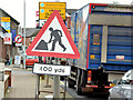
"Road works" sign, Dundonald (December 2014)
A “road works” sign, on the Upper Newtownards Road, approaching the Ballyregan Road. It refers to the new traffic lights and associated works, at the Dunlady Road junction, in connection with the new EWAY park and ride car park (opened today).
Image: © Albert Bridge
Taken: 1 Dec 2014
0.05 miles
6
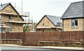
Nos 720/728 Upper Newtownards Road, Dundonald (February 2017)
Building work underway “Construction of the 30 two-bedroom apartments on the 1.6-acre site will take up 9 months to complete.” Can’t find any name (yet) for the development.
Image: © Albert Bridge
Taken: 6 Feb 2017
0.06 miles
7
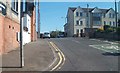
Ballyregan Road, Dundonald
The Ballyregan Road leads northwards from the main A20 Upper Newtownards Road in Dundonald village, into the hills to Craigantlet - providing a link to Holywood and the rest of North Down.
Image: © Dean Molyneaux
Taken: 12 Feb 2010
0.06 miles
8
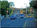
The Upper Newtownards Road (EWAY), Dundonald - June 2014(3)
The present arrangements (looking inwards) at the Church Road (left)/Upper Newtownards Road/Ballyregan Road crossroads where there are no existing bus-priority measures.
Two points strike me here. The first is that the lanes might be narrower than other parts of the road. The second is that the inward inside lane is often used for short-stay parking.
The photograph was taken during a short break in the traffic along what is usually a busy stretch. Image shows the view from the Church Road.
Image: © Albert Bridge
Taken: 28 Jun 2014
0.06 miles
9

Nos 720/728 Upper Newtownards Road, Dundonald - October 2014(1)
A hoarding, facing the Upper Newtownards Road, advising that a new development is “coming soon”.
Image: © Albert Bridge
Taken: 11 Oct 2014
0.06 miles
10

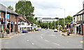
The Upper Newtownards Road (EWAY), Dundonald - June 2014(4)
See Image The view from the Church Road.
Image: © Albert Bridge
Taken: 28 Jun 2014
0.06 miles