IMAGES TAKEN NEAR TO
Upper Newtownards Road, BELFAST, BT16 1RL

Introduction

This page details the photographs taken nearby to Upper Newtownards Road, BT16 1RL by members of the Geograph project.

The Geograph project started in 2005 with the aim of publishing, organising and preserving representative images for every square kilometre of Great Britain, Ireland and the Isle of Man.

There are currently over 7.5m images from over14,400 individuals and you can help contribute to the project by visiting https://www.geograph.org.uk

Image Map


Images are licensed for reuse under creativecommons.org/licenses/by-sa/2.0
Notes
  • Clicking on the map will re-center to the selected point.
  • The higher the marker number, the further away the image location is from the centre of the postcode.

Image Listing (150 Images Found)

Images are licensed for reuse under creativecommons.org/licenses/by-sa/2.0
  • ...
Image
Details
Distance
1
Belfast Water Works access cover, Dundonald
Bearing in mind that the Belfast Water Commissioners were abolished more than 40 years ago this cover, at the Upper Newtownards Road end of St John’s Wood Park, is far from smooth and still very legible.
Image: © Albert Bridge Taken: 1 Nov 2013
0.01 miles
2
"Road works" sign, Dundonald (December 2014)
A “road works” sign, on the Upper Newtownards Road, approaching the Ballyregan Road. It refers to the new traffic lights and associated works, at the Dunlady Road junction, in connection with the new EWAY park and ride car park (opened today).
Image: © Albert Bridge Taken: 1 Dec 2014
0.02 miles
3
Stream, Dundonald (December 2014)
See Image (October 2012). The same stream, further upstream, as it enters Moat Park, behind The Lewis Image (right), from a culvert under the Upper Newtownards Road and nearby housing.
Image: © Albert Bridge Taken: 1 Dec 2014
0.03 miles
4
Ames Crosta Mills drain flap, Dundonald (December 2014)
A drain flap, at this stream Image, bearing the inscription “Ames Crosta Mills & Co Ltd”. Information, on the web, about this foundry is limited and (to an extent) repetitive. It seems to have traded from Dawson Street, Heywood, Lancs since before WW1. Best known for the production of drainage and sanitary items it also made hand grenades. The business might have been absorbed into the Babcock group http://en.wikipedia.org/wiki/Babcock_International before the 1980’s. Further information welcome. This is an interesting link about a surviving product http://www.thatchamhistoricalsociety.org.uk/enquiries/2010/ames-crosta-pump.
Image: © Albert Bridge Taken: 1 Dec 2014
0.03 miles
5
Nos 720/728 Upper Newtownards Road, Dundonald - October 2014(1)
A hoarding, facing the Upper Newtownards Road, advising that a new development is “coming soon”.
Image: © Albert Bridge Taken: 11 Oct 2014
0.04 miles
6
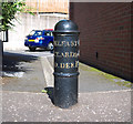
Milepost, Dundonald
Milepost on the Upper Newtownards Road, Dundonald, at the corner with St Johns Wood Park. It records that the distances to Belfast and Newtownards are both 4 miles from here; Donaghadee is 10 miles away. See also Image
Image: © Rossographer Taken: 30 Aug 2010
0.04 miles
7
Milepost, Dundonald
Milepost on the Upper Newtownards Road, Dundonald, at the corner with St Johns Wood Park. It records that the distances to Belfast and Newtownards are both 4 miles from here; Donaghadee is 10 miles away. See also Image
Image: © Rossographer Taken: 30 Aug 2010
0.04 miles
8
Autumn trees, Moat Park, Dundonald (October 2014)
See Image (October 2012). Two years later, a similar view but in flat light. Surprisingly, in view of Hurricane Gonzalo and some heavy rain, the trees have retained many of their leaves.
Image: © Albert Bridge Taken: 25 Oct 2014
0.04 miles
9
Road junction, Dundonald
Looking towards the busy junction of Church Road (foreground), Ballyregan Road (opposite) and the Upper Newtownards Road (left-right) in Dundonald.
Image: © Rossographer Taken: 6 May 2008
0.04 miles
10
Vacant shops, Dundonald (1-1)
The Upper Newtownards Road frontage of a block of vacant shops, at the corner of the Church Road. It includes a closed branch of the Northern Bank. Image shows the Church Road side.
Image: © Albert Bridge Taken: 29 Oct 2012
0.04 miles
  • ...