IMAGES TAKEN NEAR TO
Crumlin Road, BELFAST, BT14 7GD
Introduction
This page details the photographs taken nearby to Crumlin Road, BT14 7GD by members of the Geograph project.
The Geograph project started in 2005 with the aim of publishing, organising and preserving representative images for every square kilometre of Great Britain, Ireland and the Isle of Man.

There are currently over 7.5m images from over14,400 individuals and you can help contribute to the project by visiting https://www.geograph.org.uk
Image Map
Images are licensed for reuse under creativecommons.org/licenses/by-sa/2.0
Notes
- Clicking on the map will re-center to the selected point.
- The higher the marker number, the further away the image location is from the centre of the postcode.
Image Listing (14 Images Found)
Images are licensed for reuse under creativecommons.org/licenses/by-sa/2.0
Image
Details
Distance
1
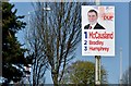
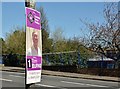
Assembly election poster, Crumlin Road, Belfast - April 2016(1)
Crumlin Road. Nelson McCausland, Paula Bradley and William Humphrey (Democratic Unionist Party).
Image: © Albert Bridge
Taken: 20 Apr 2016
0.05 miles
2
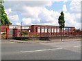
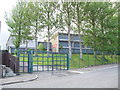
St. Gabriel's College, Ardoyne
A former Roman Catholic boys' school on the Crumlin Road. Owing to low enrollment - it sadly closed its doors in August 2008.
Image: © Dean Molyneaux
Taken: 25 Aug 2009
0.08 miles
3
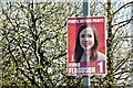
Assembly election poster, Crumlin Road, Belfast - April 2016(2)
Crumlin Road. Fiona Ferguson (People Before Profit Alliance).
Image: © Albert Bridge
Taken: 20 Apr 2016
0.11 miles
4
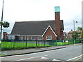
Immanuel Parish Church, Ardoyne
Along Ardoyne Road at Glenbryn. This is a Church of Ireland (Anglican) congregation sited at an 'interface' - see Image
Image: © Dean Molyneaux
Taken: 26 Aug 2009
0.13 miles
5
Assembly election poster, Crumlin Road, Belfast - April 2016(3)
Crumlin Road. Tom Burns (Independent).
Image: © Albert Bridge
Taken: 20 Apr 2016
0.13 miles
6
"The Divide", Ardoyne Road, Belfast
This is one of the most sudden and certainly one of the most contentious religious divides in Northern Ireland. In the 1960s the whole Ardoyne was a mixed area which was viewed as one step above the slums and terraces of the Shankill.
Although Protestants and Roman Catholics lived side by side as neighbours - everyone knew who was on whose side. When the conflict fired up in 1969 - suspicion arose and Protestants moved towards the northern end of the Ardoyne, towards Ballysillan which was established as Protestant. Roman Catholics, on the contrary, moved towards the Ardoyne roundabout and the Holy Cross Chapel.
This shift eventually caused an imaginary line between Alliance Avenue and Glenbryn Park. The continual violence here prompted the construction of a Peace Wall. Thankfully there has been a marked decrease in sectarian violence here since the 2001 Holy Cross dispute.
This is taken from the Protestant 'Upper Ardoyne' looking towards the Roman Catholic area - which begins roughly where the Peugeot 106 is emerging.
Image: © Dean Molyneaux
Taken: 26 Aug 2009
0.14 miles
7
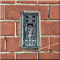
Flush Bracket, Belfast
Flush bracket bench mark on the front of the former Everton Public Elementary school on the Crumlin Road in Belfast (now part of a large Health and Social Care complex).
The number on the bracket is OSNIBM 1018.
Placed here in the 1930s, the mark only seems to appear on the 1938 plan of Belfast, levelled to 233.8 feet above sea level - unusually, I can't see it on any later maps.
Image: © Rossographer
Taken: 18 Jan 2023
0.17 miles
8
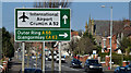
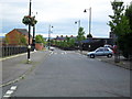
International Airport direction sign, Crumlin Road, Belfast (March 2016)
Once upon a time the Crumlin Road was the main road from Belfast to Aldergrove Airport and its predecessor at Nutt’s Corner Image The main way now, for most traffic, is via the M2 and Templepatrick Image On the other hand this is still the handiest way for many who live in north Belfast.
The sign is on the inward side of the Ballysillan Road. See also Image
Image: © Albert Bridge
Taken: 14 Mar 2016
0.18 miles
9
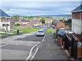
Glenbryn Park, Belfast
This is on the other side of the 'Peace Wall' visible to the right - which divides Alliance Avenue (Image) and Glenbryn Park (Roman Catholic and Protestant respectively). Since this once mixed area became a Protestant ghetto - it has become known as the Upper Ardoyne, differentiating it from the Roman Catholic Ardoyne.
Image: © Dean Molyneaux
Taken: 26 Aug 2009
0.20 miles
10
Holy Cross Girls Primary School, Ardoyne
When this school was built - the Ardoyne was a mixed (Protestant and R.C.) area. When The Troubles started and both communities moved to opposite sides of the neighbourhood - this Catholic school was left on the wrong side.
Unfortunately, in June 2001 tensions flared when local loyalist began to harass the school children and their parents while walking along the Protestant section of Ardoyne Road - eventually leading to the walk to school being undertaken between lines of riot police. The situation was eventually eased when children were permitted to enter via St Gabriel's College on the other side of the campus.
Image: © Dean Molyneaux
Taken: 26 Aug 2009
0.20 miles