IMAGES TAKEN NEAR TO
Ohio Street, BELFAST, BT13 3HT
Introduction
This page details the photographs taken nearby to Ohio Street, BT13 3HT by members of the Geograph project.
The Geograph project started in 2005 with the aim of publishing, organising and preserving representative images for every square kilometre of Great Britain, Ireland and the Isle of Man.

There are currently over 7.5m images from over14,400 individuals and you can help contribute to the project by visiting https://www.geograph.org.uk
Image Map
Images are licensed for reuse under creativecommons.org/licenses/by-sa/2.0
Notes
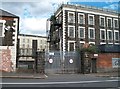
- Clicking on the map will re-center to the selected point.
- The higher the marker number, the further away the image location is from the centre of the postcode.
Image Listing (59 Images Found)
Images are licensed for reuse under creativecommons.org/licenses/by-sa/2.0
Image
Details
Distance
1
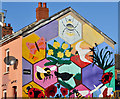
Playground mural, Belfast
A mural, showing scenes from the world of nature, near the corner of Disraeli Street and Ohio Street.
Image: © Albert Bridge
Taken: 12 Nov 2013
0.05 miles
2
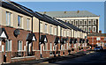
Disraeli Street, Belfast
Disraeli Street presents an interesting example of the growth of Belfast in the late 19th century. In 1877 it had 18 houses off the Crumlin Road. In 1890 there were 51. They increased to more than 160 by 1901 when it extended south to Woodvale Street. This is the recently rebuilt western side, seen from Ohio Street close to Leopold Street Image It now turns left and no longer runs through to the Crumlin Road. For reference purposes the former Brookfield Mill Image is at top right.
Image: © Albert Bridge
Taken: 12 Nov 2013
0.05 miles
3
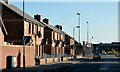
Leopold Street, Belfast
Leopold Street dates from before 1861 and once ran from Yew Street (close to the Shankill Road), across Ohio Street, to the Crumlin Road. Today’s rebuilt version is now a short cul-de-sac from Ohio Street (behind me). This is the western side.
Image: © Albert Bridge
Taken: 12 Nov 2013
0.07 miles
4
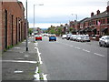
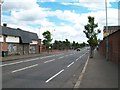
Cambrai Street, Belfast
Looking towards the Shankill Road, which Cambrai Street links with the Crumlin Road.
Image: © Dean Molyneaux
Taken: 26 Aug 2009
0.09 miles
5
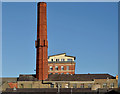
Former Edenderry Mill chimney, Belfast
Edenderry Mill, on the Crumlin Road, was built in 1865 to a design by William J Barre with three extensions between 1869 and 1914. After closure the premises were in other commercial use. Now converted to apartments called “Edenderry Lofts”. The chimney survives - seen here along Edenbrook Close from Sydney Street West. Not to be confused with this Edenderry Image
Image: © Albert Bridge
Taken: 12 Nov 2013
0.11 miles
6
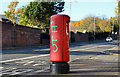
Pillar box, Rosebank, Belfast
EIIR pillar box (BT14 529), outside the former Brookfield Mill Image, on the Crumlin Road.
Image: © Albert Bridge
Taken: 12 Nov 2013
0.11 miles
7
Crumlin Road approaching the junction with the now permanently closed Flax Road
Flax Road linked the Ardoyne and the Greater Shankill area. This road was a major flashpoint and since the 1980s a permanent interface barrier closes off the road.
Image: © Eric Jones
Taken: 21 Jul 2014
0.11 miles
8
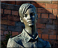
"Millie" statue, Belfast
A statue, by Ross Wilson, at the corner of Cambrai Street and the Crumlin Road, depicting a “millie” – a female mill worker. It was unveiled in May 2010.
Image: © Albert Bridge
Taken: 12 Nov 2013
0.11 miles
9
Entrance to the disused Brookmill Linen Mill
This former mill is located on the Crumlin Road.
Image: © Eric Jones
Taken: 21 Jul 2014
0.11 miles
10
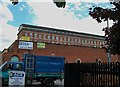
Edenderry Linen Mill, Crumlin Road
These extensive mill buildings date initially from 1865 with further additions in the period leading up to WWI. The main mill building has been converted into apartments and luxury penthouses. Another mill - Ewarts - stood on the opposite side of the Crumlin Road. This was demolished in 1999.
http://residential.btwshiells.com/KP/images/pdfs/64_671_94_ECS.pdf
Image
Image: © Eric Jones
Taken: 21 Jul 2014
0.12 miles