IMAGES TAKEN NEAR TO
Caledon Street, BELFAST, BT13 3AX
Introduction
This page details the photographs taken nearby to Caledon Street, BT13 3AX by members of the Geograph project.
The Geograph project started in 2005 with the aim of publishing, organising and preserving representative images for every square kilometre of Great Britain, Ireland and the Isle of Man.

There are currently over 7.5m images from over14,400 individuals and you can help contribute to the project by visiting https://www.geograph.org.uk
Image Map
Images are licensed for reuse under creativecommons.org/licenses/by-sa/2.0
Notes
- Clicking on the map will re-center to the selected point.
- The higher the marker number, the further away the image location is from the centre of the postcode.
Image Listing (101 Images Found)
Images are licensed for reuse under creativecommons.org/licenses/by-sa/2.0
Image
Details
Distance
1
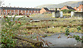
Vacant site, Lanark Way, Belfast (March 2016)
A vacant site, at the corner of Lanark Way (out of picture to the left) and the Shankill Road, to which the following planning permission applies (13 September 2013) “Z/2012/1286/F Proposed social housing development comprising 9 No.2 person 1 bedroom apartments and associated site and access works Lands at the junction of Shankhill [sic] Road/Lanark Way and bound by Caledon Street Belfast”.
Image: © Albert Bridge
Taken: 3 Mar 2016
0.05 miles
3
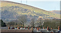
Shankill rooftops, Belfast (March 2016)
Rooftops, on the south western side of the Shankill Road, seen from Lanark Way. Divis mountain Image and Image is in the background.
Image: © Albert Bridge
Taken: 3 Mar 2016
0.07 miles
4
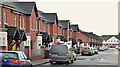
Battenberg Street, Belfast (March 2016)
A street, running from the Shankill Road (behind me) to Centurion Street, built before 1901. Originally known as Battenberg Street (no 2) to avoid confusion with Battenberg Street (no 1) off Bloomfield Avenue.
The Shankill version has been rebuilt as shown. The Bloomfield one later became Batley Street.
Image: © Albert Bridge
Taken: 3 Mar 2016
0.09 miles
5
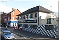
The First Shankill Northern Ireland Supporters Club, Shankill Road
Though set in the heart of the Protestant Shankill Road, the club has members from both sides of the cultural divide. Flags of the home nations are displayed on the outside of the building. Belfast has almost as many Welsh flags as Caernarfon. The uniformed gentlemen outside the club are members of an Orange Marching Band enjoying a break after a parade.
http://shankillwelcomesyou.co.uk/northern-ireland-supporters-club/
Image
Image: © Eric Jones
Taken: 19 May 2012
0.09 miles
6
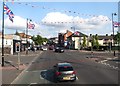
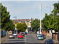
Shankill Road (B39) at the junction with Lanark Way
The 1st Shankill Northern Ireland Supporters Club can be seen on the right.
Image
Image: © Eric Jones
Taken: 19 May 2012
0.09 miles
7
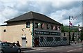
The 1st Shankill Northern Ireland Supporters Club
This is located on the Shankill Road. The flags of the Home Nations are displayed on the front of the building.
Image: © Eric Jones
Taken: 21 Jul 2014
0.09 miles
8
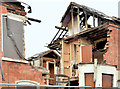
Brookmount Street, Belfast - December 2014(3)
The remains of a collapsed house on the western side of Brookmount Street.
Image: © Albert Bridge
Taken: 16 Dec 2014
0.09 miles
9
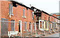
Brookmount Street, Belfast - December 2014(2)
Vacant and derelict houses on the western side of Brookmount Street.
Image: © Albert Bridge
Taken: 16 Dec 2014
0.10 miles
10
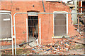
Brookmount Street, Belfast - December 2014(4)
The remains of a collapsed house on the western side of Brookmount Street.
Image: © Albert Bridge
Taken: 16 Dec 2014
0.10 miles