IMAGES TAKEN NEAR TO
Glenmachan Place, BELFAST, BT12 6QH
Introduction
This page details the photographs taken nearby to Glenmachan Place, BT12 6QH by members of the Geograph project.
The Geograph project started in 2005 with the aim of publishing, organising and preserving representative images for every square kilometre of Great Britain, Ireland and the Isle of Man.

There are currently over 7.5m images from over14,400 individuals and you can help contribute to the project by visiting https://www.geograph.org.uk
Image Map
Images are licensed for reuse under creativecommons.org/licenses/by-sa/2.0
Notes
- Clicking on the map will re-center to the selected point.
- The higher the marker number, the further away the image location is from the centre of the postcode.
Image Listing (150 Images Found)
Images are licensed for reuse under creativecommons.org/licenses/by-sa/2.0
Image
Details
Distance
1
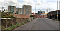
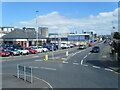
Glenmachan Place, Belfast
Part of a commercial area, near the end of the Boucher Road, between Glenmachan Street and the M1. The view is towards Broadway with Broadway Towers Image and “The Rise” http://www.geograph.org.uk/snippet/5211 in the background. The street extends further to the north east than shown on the Google map – see the hybrid satellite photograph. The Blackstaff River is behind the fence on the left.
Image: © Albert Bridge
Taken: 12 Jun 2011
0.03 miles
2
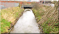
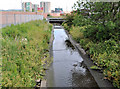
The Blackstaff River, Belfast (3)
The Blackstaff entering the culvert, on the western side of Glenmachan Place Image, taking it underground to the Lagan, near the Gasworks. The Google map is not accurate. Taken through the fence – there is no public access here.
Image: © Albert Bridge
Taken: 12 Jun 2011
0.04 miles
3
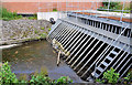
Depth gauge, the Blackstaff River, Belfast
A depth gauge, at Glenmachan Place, close to here Image The river is higher and muddier than usual after the prolonged rain during January and February.
Image: © Albert Bridge
Taken: 8 Feb 2014
0.04 miles
4
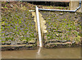
The Blackstaff River, Belfast - February 2014
The Blackstaff River, higher than usual after the prolonged rain during January and February, looking downstream at Glenmachan Place. For a contrasting summer view see Image in June 2011.
Image: © Albert Bridge
Taken: 8 Feb 2014
0.04 miles
5
The Blackstaff River, Belfast (2)
The Blackstaff, seen from a footbridge in Glenmachan Place Image, looking downstream to where it enters the culvert taking it underground to the Lagan, near the Gasworks. The Broadway Towers Image are in the background. The Google map is not accurate.
Image: © Albert Bridge
Taken: 12 Jun 2011
0.05 miles
6
Glenmachan Street from Tates Avenue roundabout
Image: © Colin Pyle
Taken: 31 Jul 2022
0.05 miles
7
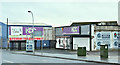
Warehouses, Glenmachan Street, Belfast (December 2017)
Warehouses on the western side of Glenmachan Street - see the shared description (below).
Image: © Albert Bridge
Taken: 17 Dec 2017
0.05 miles
8
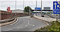
The M1, Belfast (2)
The view along what is now the south/westbound on-slip. Before the rebuilding of the Westlink Image and the construction of the Broadway underpass Image this was the start of the M1. It now starts a short distance to the north east Image
Image: © Albert Bridge
Taken: 19 Jun 2011
0.05 miles
9
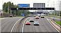
The Broadway underpass, Belfast (2)
The view, along the M1, towards Lisburn and Dungannon, from the top of the underpass. There is a variable speed limit Image here. The sign is showing “national speed limit applies” early on a Sunday morning.
Image: © Albert Bridge
Taken: 19 Jun 2011
0.06 miles
10
![Frieze, Glenmachan Street, Belfast [3]](https://s2.geograph.org.uk/photos/71/26/712650_63b26751_120x120.jpg)
Frieze, Glenmachan Street, Belfast [3]
Another frieze, this one showing runners in the Belfast marathon.
Image: © Rossographer
Taken: 3 Mar 2008
0.06 miles