IMAGES TAKEN NEAR TO
Monarch Parade, BELFAST, BT12 6GU
Introduction
This page details the photographs taken nearby to Monarch Parade, BT12 6GU by members of the Geograph project.
The Geograph project started in 2005 with the aim of publishing, organising and preserving representative images for every square kilometre of Great Britain, Ireland and the Isle of Man.

There are currently over 7.5m images from over14,400 individuals and you can help contribute to the project by visiting https://www.geograph.org.uk
Image Map
Images are licensed for reuse under creativecommons.org/licenses/by-sa/2.0
Notes
- Clicking on the map will re-center to the selected point.
- The higher the marker number, the further away the image location is from the centre of the postcode.
Image Listing (147 Images Found)
Images are licensed for reuse under creativecommons.org/licenses/by-sa/2.0
Image
Details
Distance
1
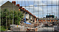
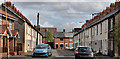
Lower Rockview Street, Belfast (1)
A major demolition underway in Lower Rockview Street (looking towards Monarch Parade), off the Donegall Road. The street seems to have been built towards the end of the 19th century. The following is an extract from an official press release: “The Minister helped demolish the first 40 houses included in the redevelopment area, which will allow for the first phase of 36 new homes to be built later this year.
Speaking in Lower Rockview Street, Donegall Road, Minister [Nelson] McCausland said: "Through its very name the Village has been an important community area in Belfast for many years. Unfortunately, the worsening housing conditions over those years led to the declaration of the Village as a redevelopment area. We are now seeing the start of the regeneration of this proud area through demolition of unfit housing to make way for new homes built to very high standards . . . . . . The Minister concluded: "The first phase involving the construction of 36 new homes will get underway later this year and will be an important milestone in the journey towards a new Village."” Image shows the street after rebuilding.
Image: © Albert Bridge
Taken: 12 Jun 2011
0.03 miles
2
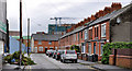
Monarch Street, Belfast
A street running from the Donegall Road to Monarch Parade (background). It seems to have been built in two phases. The first in the early 20th century. The second came along after WW1. The white wall (left) was once part of the Monarch laundry (now demolished).
Image: © Albert Bridge
Taken: 15 May 2011
0.03 miles
3
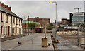
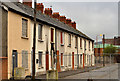
Rockland Street, Belfast (2)
See Image (June 2011). In the period since the last photograph Monarch Parade (background) and the row (right) on the eastern side of the Rockland Street have been demolished in preparation for redevelopment. Most of the street is now closed, by a fence (foreground), to the public. The row on the left is blocked up and vacant.
Image: © Albert Bridge
Taken: 8 Apr 2012
0.04 miles
4
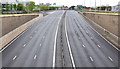
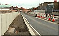
The Broadway underpass, Belfast
The view, towards the Westlink and the M2, of the underpass carrying Broadway over the M1 - previously seen in Image Taken before 09.00 on a Sunday and looking a bit quieter than this peak view Image
Image: © Albert Bridge
Taken: 5 Jun 2011
0.04 miles
5
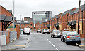
Rockland Street, Belfast
A street of terrace house, off the Donegall Road, immediately to the west of Lower Rockview Street Image Most of the houses are blocked-up and awaiting demolition. Monarch Parade is in the background. Image shows the street on 8 April 2012 after Monarch Parade and the row on the right had been demolished. Image and Image show the street after rebuilding.
Image: © Albert Bridge
Taken: 12 Jun 2011
0.04 miles
6
Rockland Street, Belfast (3)
The row on the left in Image, now blocked up and vacant, pending demolition and redevelopment.
Image: © Albert Bridge
Taken: 8 Apr 2012
0.04 miles
7
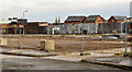
Lower Rockview Street, Belfast (3)
See Image (June 2011). All of Lower Rockview Street has now been demolished in preparation for redevelopment. The view is from Rockland Street Image
Image: © Albert Bridge
Taken: 8 Apr 2012
0.05 miles
8
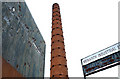
Former Monarch Laundry chimney, Belfast
Now closed and demolished, the Monarch Laundry, at the corner of the Donegall Road and Monarch Street Image, opened in 1904. After closure the premises were let to other businesses. The chimney is all that remains. Not on the “at risk” register but . . . .
Image: © Albert Bridge
Taken: 15 May 2011
0.05 miles
9
The Westlink, Belfast (16)
See Image Work is advanced on the underpass (left) to replace the Broadway roundabout. The view is towards the M2. My understanding is that there will be a south-bound off-slip (middle) and a segregated bus lane (right). With all the changes, the Google map has ceased to have much relevance.
Image: © Albert Bridge
Taken: 6 Apr 2008
0.06 miles
10
Lower Rockview Street, Belfast - February 2014
The new Lower Rockview Street. Image shows the street during demolition in June 2011.
Image: © Albert Bridge
Taken: 8 Feb 2014
0.06 miles