Lower Rockview Street, Belfast (1)
Introduction
The photograph on this page of Lower Rockview Street, Belfast (1) by Albert Bridge as part of the Geograph project.
The Geograph project started in 2005 with the aim of publishing, organising and preserving representative images for every square kilometre of Great Britain, Ireland and the Isle of Man.

There are currently over 7.5m images from over 14,400 individuals and you can help contribute to the project by visiting https://www.geograph.org.uk
Lower Rockview Street, Belfast (1)
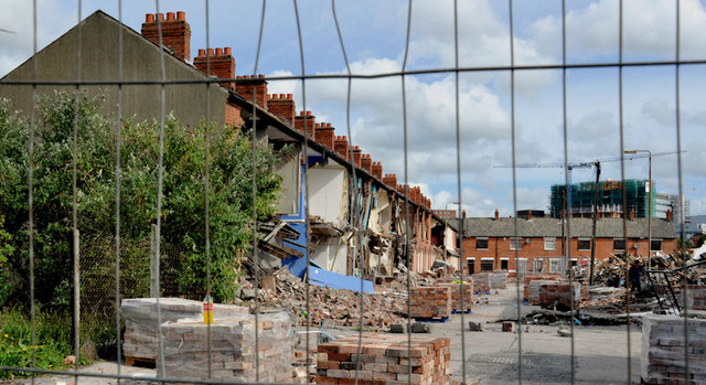
Image: © Albert Bridge Taken: 12 Jun 2011
A major demolition underway in Lower Rockview Street (looking towards Monarch Parade), off the Donegall Road. The street seems to have been built towards the end of the 19th century. The following is an extract from an official press release: “The Minister helped demolish the first 40 houses included in the redevelopment area, which will allow for the first phase of 36 new homes to be built later this year. Speaking in Lower Rockview Street, Donegall Road, Minister [Nelson] McCausland said: "Through its very name the Village has been an important community area in Belfast for many years. Unfortunately, the worsening housing conditions over those years led to the declaration of the Village as a redevelopment area. We are now seeing the start of the regeneration of this proud area through demolition of unfit housing to make way for new homes built to very high standards . . . . . . The Minister concluded: "The first phase involving the construction of 36 new homes will get underway later this year and will be an important milestone in the journey towards a new Village."” Image shows the street after rebuilding.
Images are licensed for reuse under creativecommons.org/licenses/by-sa/2.0
Image Location
Latitude
54.589834
Longitude
-5.954744