IMAGES TAKEN NEAR TO
BT1 1BX
Introduction
This page details the photographs taken nearby to BT1 1BX by members of the Geograph project.
The Geograph project started in 2005 with the aim of publishing, organising and preserving representative images for every square kilometre of Great Britain, Ireland and the Isle of Man.

There are currently over 7.5m images from over14,400 individuals and you can help contribute to the project by visiting https://www.geograph.org.uk
Image Map
Images are licensed for reuse under creativecommons.org/licenses/by-sa/2.0
Notes
- Clicking on the map will re-center to the selected point.
- The higher the marker number, the further away the image location is from the centre of the postcode.
Image Listing (3332 Images Found)
Images are licensed for reuse under creativecommons.org/licenses/by-sa/2.0
Image
Details
Distance
1
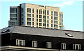
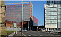
The "Obel", Belfast (9)
See Image Two symbols of the property boom before the recession. The “Obel” tower rising above the St Anne’s Square development Image seen from the grounds of the Art College.
Image: © Albert Bridge
Taken: 11 Jan 2013
0.01 miles
2
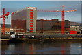
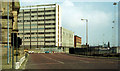
Sorting office, Tomb Street, Belfast
The sorting office at Tomb Street probably owes its location to its proximity to the old berths for the Heysham and Liverpool ferries. Most mail now travels by air and the ferries now berth much further downstream. This view (from the Lagan Weir footbridge) will not be possible once the “Obel” Image is completed. The building was re-clad a few years ago. Image shows the building under construction in 1972.
Image: © Albert Bridge
Taken: 28 Jan 2007
0.01 miles
3

Tomb Street sorting office, Belfast
See Image The windows of the sorting office catching the last light from the setting sun.
Image: © Albert Bridge
Taken: 15 Oct 2008
0.01 miles
4
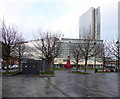
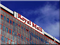
Royal Mail Building, Belfast
Looking north from Titanic Square
Image: © Kenneth Allen
Taken: 18 Dec 2017
0.01 miles
5
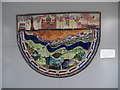
Ceramic Panel inside Laganside Bus Centre, Belfast
This photo shows a ceramic panel inside Laganside Bus Centre at Queen's Square near Donegall Quay. It was unveiled on Wednesday 1st May 1996 at the opening of the bus centre. The small notice adjacent to it gives an explanation of the items on the panel http://www.geograph.org.uk/photo/5217754 refers.
Image: © David Hillas
Taken: 9 Aug 2016
0.02 miles
6
Tomb Street sorting office, Belfast
The 'Royal Mail' sign on top of the sorting office at Tomb Street in Belfast Image
Image: © Rossographer
Taken: 7 Feb 2011
0.02 miles
7
Donegall Quay, Belfast (May 1990)
I took this with an eye on the future knowing that the scene would change with the building of the cross-harbour road and railway http://www.geograph.org.uk/snippet/5008. The red building (middle/right) was Thompson’s feed mill Image The road and railway now pass through its site. Tomb Street sorting office Image (middle/left) was later the subject of a major recladding. The “Obel” Image now occupies the site (right) of the ferry terminal http://www.geograph.org.uk/snippet/3872 where work is now underway on the construction of a new office block. The Custom House (left) remains, unchanged. For comparison see Image
Image: © Albert Bridge
Taken: 13 May 1990
0.02 miles
8
Donegall Quay, Belfast (February 2014)
See Image The same scene today. The buildings and changes are described in the link.
Image: © Albert Bridge
Taken: 27 Feb 2014
0.02 miles
9
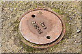
SHS access cover, Belfast (January 2015)
A small circular access cover, marked “SHS 22C 05”, at Donegall Quay. Purpose unknown but “SHS” might mean “square hollow section” http://en.wikipedia.org/wiki/Hollow_structural_section.
Image: © Albert Bridge
Taken: 25 Jan 2015
0.02 miles
10
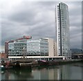
The Obel Building on Donegall Quay
This overlooks the River Lagan.
Image: © Eric Jones
Taken: 18 May 2012
0.03 miles