IMAGES TAKEN NEAR TO
Morris Close, BRISTOL, BS7 9FF
Introduction
This page details the photographs taken nearby to Morris Close, BS7 9FF by members of the Geograph project.
The Geograph project started in 2005 with the aim of publishing, organising and preserving representative images for every square kilometre of Great Britain, Ireland and the Isle of Man.

There are currently over 7.5m images from over14,400 individuals and you can help contribute to the project by visiting https://www.geograph.org.uk
Image Map
Images are licensed for reuse under creativecommons.org/licenses/by-sa/2.0
Notes
- Clicking on the map will re-center to the selected point.
- The higher the marker number, the further away the image location is from the centre of the postcode.
Image Listing (31 Images Found)
Images are licensed for reuse under creativecommons.org/licenses/by-sa/2.0
Image
Details
Distance
1
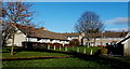
Downman Road housing, Bristol
Viewed from Morris Road.
Image: © Jaggery
Taken: 29 Dec 2013
0.02 miles
2
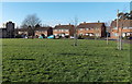
Romney Avenue houses set back from the roadway, Bristol
Houses in this part of Romney Avenue are set back about 70 metres from the main road,
behind a roughly rectangular area of grass. Danby House http://www.geograph.org.uk/photo/3799615 is in the background on the left.
Image: © Jaggery
Taken: 29 Dec 2013
0.03 miles
3
Unity Chapel, Bristol
Unity Chapel is an evangelical church on the corner of Romney Avenue and Morris Road.
Image: © Jaggery
Taken: 29 Dec 2013
0.05 miles
4
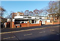
Spirit of Life Church
A Pentecostal Church on Romney Avenue, Stapleton
Image: © Eirian Evans
Taken: 21 Jan 2022
0.05 miles
5
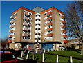
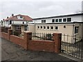
Danby House, Bristol
Block of flats in Morris Road. There is a shop at ground floor level, behind the red postbox.
Image: © Jaggery
Taken: 29 Dec 2013
0.06 miles
6
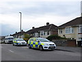
Police Vehicles Shaldon Rd
The occupants of these police cars were taking place in a police raid in a house in Shaldon Rd close to the junction with Lindsay Rd.
Image: © Nigel Mykura
Taken: 23 Feb 2013
0.08 miles
7
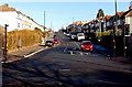
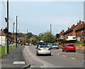
Shaldon Road, Bristol
Viewed from the B4469 Muller Road looking towards Romney Avenue.
Image: © Jaggery
Taken: 29 Dec 2013
0.10 miles
8
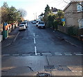
Lindsay Road, Bristol
Viewed across Shaldon Road. Not a through road, Lindsay Road leads to Crowther Road and Sir John's Lane on Pur Down.
Image: © Jaggery
Taken: 29 Dec 2013
0.11 miles
9
2011 : Romney Avenue, Bristol
Heading north east toward Lockleaze.
The round black thing near the left hand edge lights up when errant drivers exceed the 30 mph speed limit. Saw it light up once while there, waited in vain for a picture. They are all good people in Lockleaze.
Image: © Maurice Pullin
Taken: 17 Apr 2011
0.12 miles
10
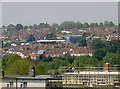
Too warm to be on the roof
Council houses in Lockleaze are being repaired, despite the sunny weather. The Memorial Stadium is in the background.
Image: © Neil Owen
Taken: 13 May 2016
0.15 miles