IMAGES TAKEN NEAR TO
Barn Owl Road, BRISTOL, BS49 4GH
Introduction
This page details the photographs taken nearby to Barn Owl Road, BS49 4GH by members of the Geograph project.
The Geograph project started in 2005 with the aim of publishing, organising and preserving representative images for every square kilometre of Great Britain, Ireland and the Isle of Man.

There are currently over 7.5m images from over14,400 individuals and you can help contribute to the project by visiting https://www.geograph.org.uk
Image Map
Images are licensed for reuse under creativecommons.org/licenses/by-sa/2.0
Notes
- Clicking on the map will re-center to the selected point.
- The higher the marker number, the further away the image location is from the centre of the postcode.
Image Listing (8 Images Found)
Images are licensed for reuse under creativecommons.org/licenses/by-sa/2.0
Image
Details
Distance
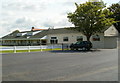
2
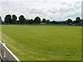
Rugby ground, Yatton
Located on the east side of North End, the local name for the B3133. The pitch is the home venue for Yatton Rugby Football Club, whose clubhouse http://www.geograph.org.uk/photo/2591833 is out of shot in the SE corner of the site. The site is shared with Yatton Netball Club, whose playing area is adjacent to the clubhouse.
Image: © Jaggery
Taken: 23 Jul 2011
0.12 miles
3
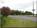
B3133 junction at the northern edge of Yatton
Viewed from the NE end of Arnold's Way. The car and lorry are heading along the B3133 away from Yatton towards North End Farm. The sign pointing right shows (central) Yatton ¾ mile, Congresbury 2¼ miles.
Image: © Jaggery
Taken: 23 Jul 2011
0.14 miles
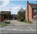
4
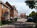
Dairy Close, Yatton
Viewed from the corner of the B3133, here named North End. Dairy Close houses were built in 2007.
Image: © Jaggery
Taken: 23 Jul 2011
0.17 miles
5
Clubhouse, Yatton Rugby Club and Netball Club
The clubhouse is located in the SE corner of the site, on the east side of the B3133. The rugby club's pitch http://www.geograph.org.uk/photo/2591820 is out of shot on the left. The netball club's playing area is beyond the far end of the clubhouse.
Image: © Jaggery
Taken: 23 Jul 2011
0.17 miles
6
Macquarie Farm Close, Yatton
A small cul-de-sac of 8 detached houses, on the west side of the B3133, opposite Yatton Rugby Football Club and Netball Club. http://www.geograph.org.uk/photo/2591833
Image: © Jaggery
Taken: 23 Jul 2011
0.21 miles
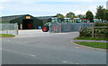
7
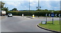
Oxford Instruments, Yatton
This is the northern entrance from the B3133 (here named North End) to the Oxford Instruments site, one of 25 offices and factories in Europe, USA, China and Japan. The company, which has about 1,250 employees worldwide, supplies high-tech instruments and systems.
As the first commercial spinoff company from Oxford University, Oxford Instruments developed the world's first superconducting magnet in 1959. This led to the development of MRI (magnetic resonance imaging) instrumentation, which was a great advance in medical diagnostics. There are now over 30,000 MRI systems in the world, a third of which have been supplied by Oxford Instruments.
Image: © Jaggery
Taken: 23 Jul 2011
0.21 miles
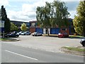
8
Tractors, Michael Burdge Limited, Yatton
A row of tractors is lined up along a perimeter fence of agricultural machine sales premises located in the NE corner of Park Farm, viewed across Arnold's Way.
Image: © Jaggery
Taken: 23 Jul 2011
0.23 miles