IMAGES TAKEN NEAR TO
Backwell Common, BRISTOL, BS48 3AE
Introduction
This page details the photographs taken nearby to Backwell Common, BS48 3AE by members of the Geograph project.
The Geograph project started in 2005 with the aim of publishing, organising and preserving representative images for every square kilometre of Great Britain, Ireland and the Isle of Man.

There are currently over 7.5m images from over14,400 individuals and you can help contribute to the project by visiting https://www.geograph.org.uk
Image Map
Images are licensed for reuse under creativecommons.org/licenses/by-sa/2.0
Notes
- Clicking on the map will re-center to the selected point.
- The higher the marker number, the further away the image location is from the centre of the postcode.
Image Listing (9 Images Found)
Images are licensed for reuse under creativecommons.org/licenses/by-sa/2.0
Image
Details
Distance
2
Spoil heap from Teague?s Colliery
My first thought was that this was the site of a motte castle, however, I believe it is the remains of a spoil heap from Teague's Colliery, an eighteenth century mine.
Image: © Philip Halling
Taken: 10 Sep 2011
0.03 miles
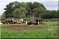
4
Backwell: Teague?s Colliery
The waste tip of an early 19th century coal mine on Backwell Common, now covered in trees. James Teague (1750-1818), its developer, was an ironmaster and owner of coal pits in the Forest of Dean. For further information see Ralph Anstis, The Industrial Teagues and the Forest of Dean, Allan Sutton, 1990. Seen from one of the numerous public footpaths in the parish
Image: © Martin Bodman
Taken: 6 Jul 2003
0.10 miles
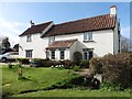
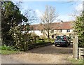
6
Field, Backwell Common
With a considerable puddle in it, a legacy of recent heavy rain. To the left is Old Farm, with a listed farmhouse http://list.english-heritage.org.uk/resultsingle.aspx?uid=1320672&searchtype=mapsearch ; on the right is the large Schrubbets Farm. Footpath LA2/24 runs between the hedges on the right.
Image: © Derek Harper
Taken: 23 Nov 2012
0.18 miles
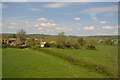
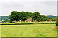
7
Cider Farm, Backwell Common
See also Image, also taken from the main railway line. The C17 farmhouse, in the centre, is listed https://historicengland.org.uk/listing/the-list/list-entry/1129807 . Footpath LA2 36/30 runs alongside the hedge in the foreground and between the farm buildings.
Image: © Derek Harper
Taken: 1 Apr 2019
0.22 miles
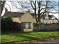
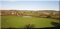
8
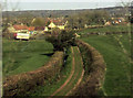
Track, Backwell Common
Carrying footpath LA2 24/30 beneath the railway from which this was taken, towards the listed Old Farm https://historicengland.org.uk/listing/the-list/list-entry/1320672 , which is also seen in Image
Image: © Derek Harper
Taken: 1 Apr 2019
0.23 miles