IMAGES TAKEN NEAR TO
Castle Farm Lane, BRISTOL, BS41 8LU
Introduction
This page details the photographs taken nearby to Castle Farm Lane, BS41 8LU by members of the Geograph project.
The Geograph project started in 2005 with the aim of publishing, organising and preserving representative images for every square kilometre of Great Britain, Ireland and the Isle of Man.

There are currently over 7.5m images from over14,400 individuals and you can help contribute to the project by visiting https://www.geograph.org.uk
Image Map
Images are licensed for reuse under creativecommons.org/licenses/by-sa/2.0
Notes
- Clicking on the map will re-center to the selected point.
- The higher the marker number, the further away the image location is from the centre of the postcode.
Image Listing (28 Images Found)
Images are licensed for reuse under creativecommons.org/licenses/by-sa/2.0
Image
Details
Distance
1
Monarch's Way sticker
A rather less expensive marker on the footpath around Dundry. The route is over 600 miles long and largely recreates the path taken by King Charles II as he fled from the Battle of Worcester in 1651. Not sure this sticker will remain in place for too long, but then there must be a lot of them needed so the cost must have been decisive.
Image: © Neil Owen
Taken: 5 May 2016
0.11 miles
2
Don't contaminate my land
A slight alternative to the usual notices - access is not permitted as a Covid-19 precaution.
Image: © Neil Owen
Taken: 10 Nov 2020
0.11 miles
3
Towards the masts, Dundry Down
The transmitter masts are more clearly shown at Image This view is from the Monarch's Way close to where Image] was taken.
Image: © Derek Harper
Taken: 25 Nov 2019
0.11 miles
4
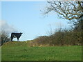
A little cow on a little hill
Dundry is a high point at the south of Bristol, affording sweeping views and inquisitive cows.
Image: © Neil Owen
Taken: 10 Nov 2020
0.11 miles
5
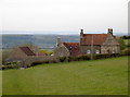
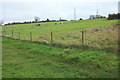
Castle Farm
Taking an expansive panorama from the west of Dundry, the farm has an interesting mix of farm animals.
Image: © Neil Owen
Taken: 5 May 2016
0.12 miles
6
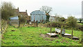
Castle Farm
Taken a little further along the Monarch's Way from Image] as it reaches the farm on restricted byway LA7 44/10, with a drinking trough on the right.
Image: © Derek Harper
Taken: 25 Nov 2019
0.13 miles
7
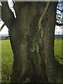
A sturdy heart
An old tree on Elwell Lane shows that its heart is in the right place.
Image: © Neil Owen
Taken: 10 Nov 2020
0.13 miles
8
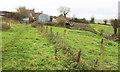
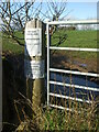
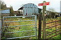
Castle Farm
The Monarch's Way follows restricted byway LA7 44/10 through the farm. The farmhouse at the rear is listed https://historicengland.org.uk/listing/the-list/list-entry/1320997 . But where was the castle?
On the right is the start of the belt of trees shown in Image]; the spring mentioned must be close to the gate. Public footpaths join the byway from either side in the next few metres.
Image: © Derek Harper
Taken: 25 Nov 2019
0.13 miles
9
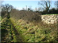
Elwell Lane
Leading down the hill to the spring.
Image: © Neil Owen
Taken: 10 Nov 2020
0.13 miles
10
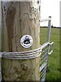
Byway signs, Castle Farm
The farm is also shown at Image] and Image As the lower waymark shows, restricted byway LA7 44/10 is followed by the Dundry Hilltop Walk, although this doesn't quite match the route shown at http://www.dundry.org.uk/parish_council/Dundry%20Walk.pdf . The upper waymark is a faded blue; there should be one for the Monarch's Way, and although they are usually yellow, some are blue.
Image: © Derek Harper
Taken: 25 Nov 2019
0.13 miles