IMAGES TAKEN NEAR TO
The Steps, BRISTOL, BS41 8JB
Introduction
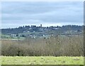
This page details the photographs taken nearby to The Steps, BS41 8JB by members of the Geograph project.
The Geograph project started in 2005 with the aim of publishing, organising and preserving representative images for every square kilometre of Great Britain, Ireland and the Isle of Man.

There are currently over 7.5m images from over14,400 individuals and you can help contribute to the project by visiting https://www.geograph.org.uk
Image Map
Images are licensed for reuse under creativecommons.org/licenses/by-sa/2.0
Notes
- Clicking on the map will re-center to the selected point.
- The higher the marker number, the further away the image location is from the centre of the postcode.
Image Listing (93 Images Found)
Images are licensed for reuse under creativecommons.org/licenses/by-sa/2.0
Image
Details
Distance
1
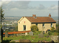
2009 : Cottages on Hill Road, Dundry
Looking across a corner of the churchyard.
Bristol is in the background, the orange "thing" near the left hand edge is a sign marking a "B&Q" warehouse.
Image: © Maurice Pullin
Taken: 26 May 2009
0.03 miles
2
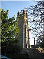
Dundry Church
Built on a prominent ridge, south of Bristol, this church has an unusually ornate tower, making it a prominent landmark.
Image: © Dr Duncan Pepper
Taken: 28 Sep 2008
0.04 miles
3
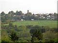
Dundry slopes
The ridge of land that Dundry village occupies has some fairly gentle slopes around it except for those immediately north of it. Houses cling to the gradient and take advantage of the fabulous views of Bristol. St Michael's church tower is one of the more prominent landmarks.
Image: © Neil Owen
Taken: 12 May 2016
0.05 miles
4
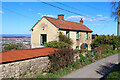
Hill Road
Dwelling on Hill Road, Dundry.
Image: © Wayland Smith
Taken: 5 Apr 2021
0.06 miles
6
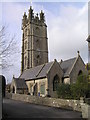
Church of St Michael, Dundry
The four-stage tower is a prominent feature in its hill-top position with its tower visible for many miles around. The four-stage tower was erected, around 1448 by the Society of Merchant Venturers of Bristol as a landmark and is visible from many parts of Avon.
More information see http://en.wikipedia.org/wiki/Dundry
Image: © Rick Crowley
Taken: 2 Nov 2010
0.06 miles
7
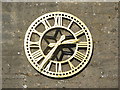
Dundry Church Clock
Most of the photos found in this grid feature Dundry Church (interesting information about the Church itself can be found on the link below). This photo provides a close-up of the clock on the south wall of the Tower, installed in 1999 to celebrate the millennium.
http://www.jobdone.org.uk/dundryweb/then_now/about_dundry.htm
Image: © MD
Taken: 12 Oct 2008
0.06 miles
8
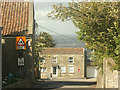
2009 : Church Road, Dundry
Looking north to the end (or the beginning) of Church Road.
Bristol is lurking in the background under a convenient cloud.
Image: © Maurice Pullin
Taken: 26 May 2009
0.06 miles
9
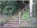
Mystery of the Steps at Dundry
Who undertook this major task of constructing 147 steps, giving a staircase from the lower field footpaths to the centre of the village is still a mystery. The hard pennant stone used must have been carried up the hill by horse and cart for a minimum of 3 miles. The steps would have helped labour to reach the centre of the village from the footpath below to the quarries or for a major project.
Details and 1912 photo at http://www.dundry.org.uk/taste_dundry.htm
Image: © Rick Crowley
Taken: 2 Nov 2010
0.06 miles
10
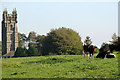
Holy cow
This photo shows part of Dundry church as seen from Dundry Down. After walking across this field we found a sign that had fallen off the stile - 'Bull in field with cows - NO ACCESS'.
Image: © MD
Taken: 12 Oct 2008
0.07 miles