IMAGES TAKEN NEAR TO
Lower Langford, BRISTOL, BS40 5BL
Introduction
This page details the photographs taken nearby to Lower Langford, BS40 5BL by members of the Geograph project.
The Geograph project started in 2005 with the aim of publishing, organising and preserving representative images for every square kilometre of Great Britain, Ireland and the Isle of Man.

There are currently over 7.5m images from over14,400 individuals and you can help contribute to the project by visiting https://www.geograph.org.uk
Image Map (Loading...)


Getting Data...Please wait
Leaflet Map data © OpenStreetMap
Images are licensed for reuse under creativecommons.org/licenses/by-sa/2.0
Notes
- Clicking on the map will re-center to the selected point.
- The higher the marker number, the further away the image location is from the centre of the postcode.
Image Listing (19 Images Found)
Images are licensed for reuse under creativecommons.org/licenses/by-sa/2.0
Image
Details
Distance
1
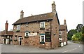
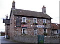
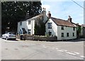
Langford Inn
A pub in Lower Langford on Langford Road, seen bending towards the junction with Blackmoor.
Image: © Derek Harper
Taken: 16 May 2011
0.01 miles
2
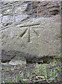
Benchmark low down in Langford
A cutmark, as listed in the Benchmark Database: http://www.bench-marks.org.uk/bm41363 , at the foot of the Langford Inn. See Image] for a wider view.
Image: © Neil Owen
Taken: 23 Jan 2012
0.01 miles
4
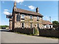
The Langford Inn
This country inn has won several 'Best Country Pub' awards in recent years. Located at the base of the inn where it meets the garden wall is a benchmark. See Image] for a look.
Image: © Neil Owen
Taken: 23 Jan 2012
0.03 miles
5
Old Direction Sign - Signpost by Langford Road, Lower Langford
Pyramid finial - 3 arms, 1 broken off; Somerset SCC pyramid by the UC road, in parish of Churchill (North Somerset District), Langford Road junction with Blackmoor, in Lower Langford. Adjacent to village pump and mounting steps.
Surveyed
Milestone Society National ID: SO_ST4660
Image: © Milestone Society
Taken: Unknown
0.04 miles
6
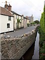
Langford Brook, Blackmoor
From the bridge at the junction with Langford Lane. The brook (flowing away from the camera) runs on one side of the road; on the other are cottages and Langford Evangelical Church.
Image: © Derek Harper
Taken: 16 May 2011
0.05 miles
7
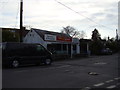
The Tog Store
Langford Road, Lower Langford.
Specializing in outdoor activity clothing.
Image: © Anthony Vosper
Taken: 17 Mar 2013
0.05 miles
9
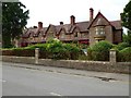
Victoria Jubilee Langford Homes
Victorian Almshouses dating from 1887. The building is Grade II listed.
Historic England description
Almshouses. Dated 1887 (on cartouche). Possibly by Foster and Wood of Bristol. Finely jointed squared and coursed dressed stone with ashlar dressings, wooden bargeboards and loggias, dressed stone copings, plain tile roofs and brick stacks. Free-form Gothic style. 2-storey, 9-bay south front with end bays advanced and central gabled section with ornate cartouche. Windows are cross-mullions with plate glass lights throughout, those to alternate bays on ground floor in canted bays, those to end sections in semi-circular bays. Upper alternate windows under gables. Lean-to roof over ground floor windows with 3 round-arched loggias: 4 plank doors, bracketted eaves cornice, steeply pitched gabled roof with tall panelled stacks. Porches to east and west return fronts and statue of Queen Victoria above west porch. Erected at the expense of Sidney Hill of Langford House (q.v.).
Source: https://www.historicengland.org.uk/listing/the-list/list-entry/1320910
Image: © Philip Halling
Taken: 6 Jun 2016
0.08 miles
10
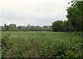
Field, Blackmoor
From the road shown in Image, looking across Langford Brook, with a line of trees along the field boundary to the right, which is followed by a parish boundary. The brook is also a parish boundary. So the camera is in Churchill parish, the field is in Wrington, and behind the trees is Burrington parish.
Image: © Derek Harper
Taken: 16 May 2011
0.08 miles