IMAGES TAKEN NEAR TO
Hayboro Way, BRISTOL, BS39 7TB
Introduction
This page details the photographs taken nearby to Hayboro Way, BS39 7TB by members of the Geograph project.
The Geograph project started in 2005 with the aim of publishing, organising and preserving representative images for every square kilometre of Great Britain, Ireland and the Isle of Man.

There are currently over 7.5m images from over14,400 individuals and you can help contribute to the project by visiting https://www.geograph.org.uk
Image Map (Loading...)


Getting Data...Please wait
Leaflet Map data © OpenStreetMap
Images are licensed for reuse under creativecommons.org/licenses/by-sa/2.0
Notes
- Clicking on the map will re-center to the selected point.
- The higher the marker number, the further away the image location is from the centre of the postcode.
Image Listing (6 Images Found)
Images are licensed for reuse under creativecommons.org/licenses/by-sa/2.0
Image
Details
Distance
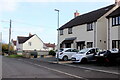
1
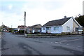
Houses on Winterfield Park
Winterfield Park is one of a number of small residential roads just off Winterfield Road, the B3355, on the southern edge of Paulton. This bungalow is at the junction with Oaklands.
Image: © Nigel Mykura
Taken: 2 Nov 2020
0.10 miles
2
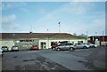
Paulton Rovers Football Club
Image: © Dominic Dawn Harry and Jacob Paterson
Taken: 18 Feb 2006
0.15 miles
3
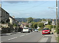
2009 : B3355 Salisbury Road, Paulton
Looking north toward the town centre.
Image: © Maurice Pullin
Taken: 10 Oct 2009
0.17 miles
4
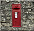
2009 : George V wall postbox, Salisbury Road, Paulton
Recently painted, neatly done.
Image: © Maurice Pullin
Taken: 10 Oct 2009
0.19 miles
5
Houses on Clandown Rd
Clandown Rd runs east from the Salisbury Rd, the B3355, on the southern edge of Paulton to Springfield farm where it meets Monger Lane and just beyond which it splits into Lovers Lane and Water Lane.
Image: © Nigel Mykura
Taken: 2 Nov 2020
0.24 miles
6
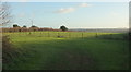
Fields by Old Mills Lane
Thesse are immediately south of the Miners Welfare Recreation Ground shown in Image
Image: © Derek Harper
Taken: 9 Dec 2019
0.25 miles