IMAGES TAKEN NEAR TO
Jubilee Terrace, BRISTOL, BS39 7NU
Introduction
This page details the photographs taken nearby to Jubilee Terrace, BS39 7NU by members of the Geograph project.
The Geograph project started in 2005 with the aim of publishing, organising and preserving representative images for every square kilometre of Great Britain, Ireland and the Isle of Man.

There are currently over 7.5m images from over14,400 individuals and you can help contribute to the project by visiting https://www.geograph.org.uk
Image Map (Loading...)


Getting Data...Please wait
Leaflet Map data © OpenStreetMap
Images are licensed for reuse under creativecommons.org/licenses/by-sa/2.0
Notes
- Clicking on the map will re-center to the selected point.
- The higher the marker number, the further away the image location is from the centre of the postcode.
Image Listing (41 Images Found)
Images are licensed for reuse under creativecommons.org/licenses/by-sa/2.0
Image
Details
Distance
1
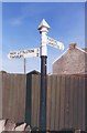
Old Direction Sign - Signpost in Plummer's Hill, Paulton
Pyramid finial - 2 arms; Somerset SCC pyramid by the UC road, in parish of Paulton (Bath And North East Somerset District), on the northeast side of the Y junction of Bath Road and Bristol Road in Plummer's Hill.
surveyed
Milestone Society National ID: SO_ST6556
Image: © Milestone Society
Taken: Unknown
0.04 miles
2
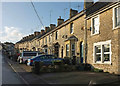
Bath Road, Paulton
Part of a terrace of 24.
Image: © Derek Harper
Taken: 9 Dec 2019
0.07 miles
3
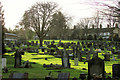
Cemetery, Paulton
Dating from 1882 and described at https://www.batharchives.co.uk/cemeteries/paulton-cemetery . The houses are on High Street.
Image: © Derek Harper
Taken: 9 Dec 2019
0.07 miles
4
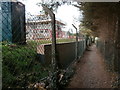
Path towards Cam Valley playing fields
Today the gate shown at Image was open, giving access to this path, popular with dog walkers, which would once have skirted Purnell's printing works. The area of the former works has had housing built on it, and this adjacent area is also being built on. Paulton must have had a considerable expansion of population in recent years, but despite this many of the shops in the village have closed and it has lost its post office.
Image: © HelenK
Taken: 30 Sep 2018
0.08 miles
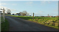
5
Entrance to sports club, Paulton
Purnell Sports Club is by Bristol Road.
Image: © Derek Harper
Taken: 9 Dec 2019
0.11 miles
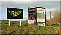
6
Notices, sports club, Paulton
By the entrance drive shown in Image
Image: © Derek Harper
Taken: 9 Dec 2019
0.11 miles
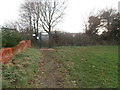
7
The boundary of Cam Valley playing fields
This playing field is now a fenced off area used for matches by Purnell Sports Youth. This organisation is named after Purnell's, the printers whose works were located in the area beyond this fence until 2005. There is no access to the playing field when it is not in use, and this gate, which opens onto a public footpath, was padlocked. Beyond the footpath more housing is being built.
Image: © HelenK
Taken: 14 Jan 2018
0.13 miles
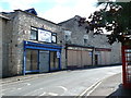
8
Closed Shops in Paulton
These shops on the Bath Road, a baker, a betting shop and a pine furniture shop have all closed. They occupy some old stone buildings. There are sold signs on two of them so perhaps the site will be developed.
Image: © Nigel Mykura
Taken: 18 Sep 2011
0.13 miles
9
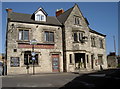
The Red Lion, Paulton
Occupying a prime site at the top of town. See Image] for a detail.
Image: © Neil Owen
Taken: 11 Oct 2016
0.14 miles
10
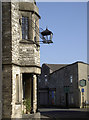
A guiding light for the thirsty
The ornate light outside the Red Lion. See Image] for a fuller view.
Image: © Neil Owen
Taken: 11 Oct 2016
0.14 miles