IMAGES TAKEN NEAR TO
Pensford Hill, BRISTOL, BS39 4AB
Introduction
This page details the photographs taken nearby to Pensford Hill, BS39 4AB by members of the Geograph project.
The Geograph project started in 2005 with the aim of publishing, organising and preserving representative images for every square kilometre of Great Britain, Ireland and the Isle of Man.

There are currently over 7.5m images from over14,400 individuals and you can help contribute to the project by visiting https://www.geograph.org.uk
Image Map
Images are licensed for reuse under creativecommons.org/licenses/by-sa/2.0
Notes
- Clicking on the map will re-center to the selected point.
- The higher the marker number, the further away the image location is from the centre of the postcode.
Image Listing (115 Images Found)
Images are licensed for reuse under creativecommons.org/licenses/by-sa/2.0
Image
Details
Distance
2
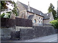
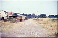
The old Wesleyan methodist chapel
Pensford was served by a few churches but this one is now longer open to worship. A benchmark used to be close to the road entrance to the left of shot, but was later replaced with one on the wall by the wooden gate - see Image
Image: © Neil Owen
Taken: 28 Jul 2011
0.06 miles
3
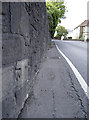
Pensford Hill benchmark
Cut into the walling of a former Methodist chapel. See Image] for a look at the chapel and http://www.bench-marks.org.uk/bm54741 for the entry in the Benchmark Database.
Image: © Neil Owen
Taken: 28 Jul 2011
0.06 miles
4
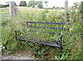
Not many visitors
A bench, halfway down the hill and facing the traffic-choked A37 instead of the fields behind it.
Image: © Neil Owen
Taken: 28 Jul 2011
0.10 miles
5
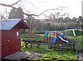
Pensford playground
Close to the Recreation Ground, Memorial Hall and the tennis courts, this children's playground is too cold for visitors today.
Image: © Neil Owen
Taken: 2 Feb 2016
0.12 miles
6
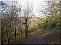
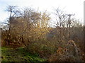
In Culvery Wood
Looking north through the newer area of trees: this part was planted in a Millennium project by the Woodland Trust. There were many hornbeams here and were complemented by fresh additions. The woodland originally was on the lower slopes by the River Chew and was once known as Calvary Wood in the 1800s.
Image: © Neil Owen
Taken: 7 Jan 2018
0.12 miles
7
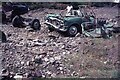
Aftermath of the July 68 floods at Pensford
The devastating floods of July 1968 swepted away the A37 road bridge at Pensford but the older bridge in the centre of the village survived. The Army were soon involved with building a Bailey Bridge to span the River Chew. This is all that were left of cars that were swept away by the flood and deposited here. The information is documented on the following link;- https://en.wikipedia.org/wiki/Chew_Stoke_flood_of_1968
Image: © Richard Park
Taken: Unknown
0.13 miles
8
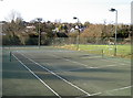
Pensford Tennis courts
The local club, formed in 1995, serves many of the surrounding villages too. The all-weather courts are available for hire when not used for coaching.
Image: © Neil Owen
Taken: 2 Feb 2016
0.13 miles
9
In Culvery Wood
The upper reaches of this little piece of woodland runs alongside the old railway line and viaduct in Pensford. It was bought and planted by the Woodland Trust in 1997 in order to create a new area of woodland for the millennium. Supported by various funds and grants, the land was planted with new oak, ash, field maple and plenty of hornbeam,
Image: © Neil Owen
Taken: 7 Jan 2018
0.13 miles
10
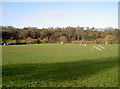
In between games
Pensford Recreation Ground offers plenty of room for several games and training facilities.
Image: © Neil Owen
Taken: 2 Feb 2016
0.13 miles