IMAGES TAKEN NEAR TO
Pensford Hill, BRISTOL, BS39 4AA
Introduction
This page details the photographs taken nearby to Pensford Hill, BS39 4AA by members of the Geograph project.
The Geograph project started in 2005 with the aim of publishing, organising and preserving representative images for every square kilometre of Great Britain, Ireland and the Isle of Man.

There are currently over 7.5m images from over14,400 individuals and you can help contribute to the project by visiting https://www.geograph.org.uk
Image Map
Images are licensed for reuse under creativecommons.org/licenses/by-sa/2.0
Notes
- Clicking on the map will re-center to the selected point.
- The higher the marker number, the further away the image location is from the centre of the postcode.
Image Listing (115 Images Found)
Images are licensed for reuse under creativecommons.org/licenses/by-sa/2.0
Image
Details
Distance
1
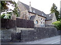
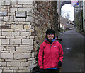
The old Wesleyan methodist chapel
Pensford was served by a few churches but this one is now longer open to worship. A benchmark used to be close to the road entrance to the left of shot, but was later replaced with one on the wall by the wooden gate - see Image
Image: © Neil Owen
Taken: 28 Jul 2011
0.02 miles
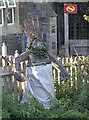
2
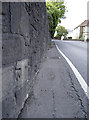
Pensford Hill benchmark
Cut into the walling of a former Methodist chapel. See Image] for a look at the chapel and http://www.bench-marks.org.uk/bm54741 for the entry in the Benchmark Database.
Image: © Neil Owen
Taken: 28 Jul 2011
0.02 miles
3
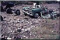
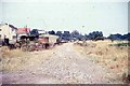
Aftermath of the July 68 floods at Pensford
The devastating floods of July 1968 swepted away the A37 road bridge at Pensford but the older bridge in the centre of the village survived. The Army were soon involved with building a Bailey Bridge to span the River Chew. This is all that were left of cars that were swept away by the flood and deposited here. The information is documented on the following link;- https://en.wikipedia.org/wiki/Chew_Stoke_flood_of_1968
Image: © Richard Park
Taken: Unknown
0.07 miles
4
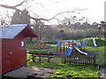
Pensford playground
Close to the Recreation Ground, Memorial Hall and the tennis courts, this children's playground is too cold for visitors today.
Image: © Neil Owen
Taken: 2 Feb 2016
0.08 miles
5
Flood Level at Pensford 10th and 11th July 1968
The level is shown on the plaque on the wall top left. Part of Pensford viaduct is also shown. Bristol and North Somerset Railway, built the viaduct in 1873 but closed to trains in 1968 after the flood made it supposedly unsafe.
Image: © Rick Crowley
Taken: 18 Feb 2009
0.08 miles
7
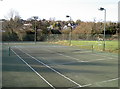
Pensford Tennis courts
The local club, formed in 1995, serves many of the surrounding villages too. The all-weather courts are available for hire when not used for coaching.
Image: © Neil Owen
Taken: 2 Feb 2016
0.10 miles
8

2010 : A37 about to cross the River Chew at Pensford
Heading toward Whitchurch and Bristol.
"PENSFORD ST. THOMAS, a parish in the hundred of Keynsham, county Somerset, 6 miles S. of Bristol. The parish, which is of small extent, is intersected by the river Chew. The village, which was formerly a market town, is situated partly in this and partly in the adjoining parish of Publow. The woollen cloth manufacture was formerly carried on here; but has long since declined. The inhabitants are now chiefly engaged in the adjacent collieries and copper mines. Several of the adherents of the unfortunate Duke of Monmouth were executed here by Jeffreys. The living is a curacy annexed to the vic, of Stanton-Drew, in the diocese of Bath and Wells. The church, dedicated to St. Thomas-a-Becket, is a stone structure with a venerable tower. There are places of worship for the Independents and Wesleyans. Fairs are held on the 6th May and 8th November." From The National Gazetteer of Great Britain and Ireland (1868) Transcribed by Colin Hinson © 2003"
The above was copied from: http://www.genuki.org.uk/big/eng/SOM/Pensford/index.html
Image: © Maurice Pullin
Taken: 5 Jul 2010
0.10 miles
9
The modern game
Pensford clearly has embraced the women's game as much as the men's, equality and all that. Or is it a sly swipe at the officials' performances?
Image: © Neil Owen
Taken: 2 Feb 2016
0.10 miles
10
Bridge Troll!
Lurking mischievously by the bridge over the River Chew and taking up residence beside the primary school, a troll waits eagerly for passing goats to assail. See Image] for a warning sign.
Image: © Neil Owen
Taken: 3 Oct 2016
0.10 miles