IMAGES TAKEN NEAR TO
Pitchcombe, BRISTOL, BS37 4JU
Introduction
This page details the photographs taken nearby to Pitchcombe, BS37 4JU by members of the Geograph project.
The Geograph project started in 2005 with the aim of publishing, organising and preserving representative images for every square kilometre of Great Britain, Ireland and the Isle of Man.

There are currently over 7.5m images from over14,400 individuals and you can help contribute to the project by visiting https://www.geograph.org.uk
Image Map
Images are licensed for reuse under creativecommons.org/licenses/by-sa/2.0
Notes
- Clicking on the map will re-center to the selected point.
- The higher the marker number, the further away the image location is from the centre of the postcode.
Image Listing (7 Images Found)
Images are licensed for reuse under creativecommons.org/licenses/by-sa/2.0
Image
Details
Distance
2
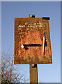
No motor cycles
Although you would have to stare pretty hard at this neglected sign to read it.
Image: © Neil Owen
Taken: 28 Nov 2016
0.16 miles
3
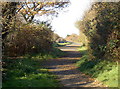
Will it ever be a road?
As part of the development of Yate in the 1970s, it was planned to have a dual carriageway linking the roundabout to the main road and railway station. However, the idea didn't have the backing and the finances were found wanting - hence the roads were partially laid but never completed. Today they are a peaceful and popular walk. There has been recent talk of the council making the effort to complete the link, although many local residents have yet to be convinced.
Image: © Neil Owen
Taken: 28 Nov 2016
0.16 miles
4
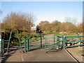
Gates to the Common
Yate Common, with some hefty ironmongery to prevent unwanted vehicular access. This was to have been the end of a dual carriageway leading from the roundabout, but the plans and the money were found insufficient before work finished - hence it is a peaceful path.
Image: © Neil Owen
Taken: 28 Nov 2016
0.17 miles
5
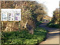
Welcome to the Common Yate
Some handy information from South Gloucestershire Council. The area is on the edge of the expanse of the common and has some paths for travelling to the west of the town. See Image] for a look at the marker.
Image: © Neil Owen
Taken: 28 Nov 2016
0.17 miles
6
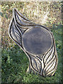
Fields in Trust
An elaborately carved marker, explaining that the common is designated as Fields in Trust, 2012. Hopefully it will remain so even if the proposed roads that were started but never finished are finally to be built here.
Image: © Neil Owen
Taken: 28 Nov 2016
0.17 miles
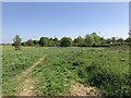
7
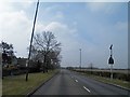
Westerleigh Road, Yate
On the right is the large open space of Westerleigh Common.
Image: © Steve Fareham
Taken: 9 Apr 2013
0.23 miles