IMAGES TAKEN NEAR TO
Badminton Road, BRISTOL, BS36 1AL
Introduction
This page details the photographs taken nearby to Badminton Road, BS36 1AL by members of the Geograph project.
The Geograph project started in 2005 with the aim of publishing, organising and preserving representative images for every square kilometre of Great Britain, Ireland and the Isle of Man.

There are currently over 7.5m images from over14,400 individuals and you can help contribute to the project by visiting https://www.geograph.org.uk
Image Map
Images are licensed for reuse under creativecommons.org/licenses/by-sa/2.0
Notes
- Clicking on the map will re-center to the selected point.
- The higher the marker number, the further away the image location is from the centre of the postcode.
Image Listing (16 Images Found)
Images are licensed for reuse under creativecommons.org/licenses/by-sa/2.0
Image
Details
Distance
1
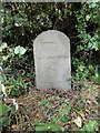
Old Milestone by UC road (was A432), on old course of road, back of verge, in the hedge, by no.17 Badminton Road
The Milestone is located by the road on the West of the road. Parish of Westerleigh (South Gloucestershire District). Stone post (plate lost), design, erected by the Bristol turnpike trust in the 19th Century.
Inscription reads:-
To / Bristol / 6 / miles
Milestone Society National ID: GL_BRSY06
Image: © Roadside Relics
Taken: 6 Jul 2023
0.09 miles
2
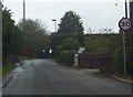
Cuckoo Lane
This tranquil looking rural lane is only about 200 metres from both the busy A432 Badminton Road and the M4 motorway.
Image: © Ruth Riddle
Taken: 4 May 2012
0.12 miles
3
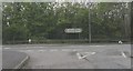
Dreary and grey
Two rather grubby greying signs above a grey expanse of the A432 Badminton Road at its junction with Cuckoo Lane on a dismal and grey day in May!
Image: © Ruth Riddle
Taken: 4 May 2012
0.14 miles
4
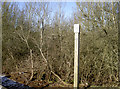
No cut in Cuckoo Lane
A notice states that there should be no cutting of the undergrowth from 1st February to 31st July as it is an area of nature conservation interest. Beyond is the valley leading to Folly Brook.
Image: © Neil Owen
Taken: 7 Feb 2018
0.15 miles
5
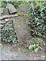
Old Boundary Marker on Cuckoo Lane, Winterbourne Down
Boundary Marker in a low wall by the entrance to Mill Lodge on the east side of Cuckoo Lane, Winterbourne Down. On the former boundary of Mangotsfield and Stoke Gifford parishes but now entirely in Winterbourne parish.
Milestone Society National ID: GL_WINT05bm
Image: © Roadside Relics
Taken: 6 Jul 2023
0.15 miles

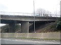
7

Moorend : M4 Motorway
A man inspects his vehicle.
Image: © Lewis Clarke
Taken: 18 Oct 2022
0.17 miles
8
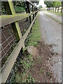
Old Boundary Marker at Bury Hill Farm, Winterbourne Down
Boundary Marker beside the drive and public footpath leading to Bury Hill Farm. Winterbourne parish. No visible inscription. Thought to have been moved here.
Milestone Society National ID: GL_WINT04bm
Image: © Roadside Relics
Taken: 6 Jul 2023
0.17 miles