IMAGES TAKEN NEAR TO
Rock Lane, BRISTOL, BS34 8PG
Introduction
This page details the photographs taken nearby to Rock Lane, BS34 8PG by members of the Geograph project.
The Geograph project started in 2005 with the aim of publishing, organising and preserving representative images for every square kilometre of Great Britain, Ireland and the Isle of Man.

There are currently over 7.5m images from over14,400 individuals and you can help contribute to the project by visiting https://www.geograph.org.uk
Image Map (Loading...)


Getting Data...Please wait
Leaflet Map data © OpenStreetMap
Images are licensed for reuse under creativecommons.org/licenses/by-sa/2.0
Notes
- Clicking on the map will re-center to the selected point.
- The higher the marker number, the further away the image location is from the centre of the postcode.
Image Listing (37 Images Found)
Images are licensed for reuse under creativecommons.org/licenses/by-sa/2.0
Image
Details
Distance
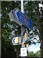
1
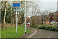
Path junction, Stoke Gifford
A reverse view of Image], with the signs and dog bin, and the scene in Image] in the background. Footpath LSG 7/20 is ahead.
Image: © Derek Harper
Taken: 3 Mar 2020
0.06 miles
2
Path junction, Stoke Gifford
The junction seen ahead in Image]; footpath LSG 8/50 turns left here. The chicane railings, along a very short stretch of path, numbered LSG 7/10, allow access to Rock Lane, used by the Community Forest Path. Image] is a reverse view.
Image: © Derek Harper
Taken: 3 Mar 2020
0.06 miles
3
Path, Stoke Gifford
Footpath LSG 8/50 reaches a T junction where it follows the path to the right Image I think the house on the right is on Simmonds View.
Image: © Derek Harper
Taken: 3 Mar 2020
0.06 miles
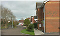
4
Footpath and cul-de-sac, Stoke Gifford
Footpath LSG 7/20 reaches Simmonds View.
Image: © Derek Harper
Taken: 3 Mar 2020
0.07 miles
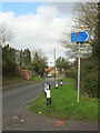
5
A popular post
Lots of advice and information, including what appears to be colour-coded cycle routes.
Image: © Neil Owen
Taken: 25 May 2019
0.08 miles
6
Simmonds Way, Stoke Gifford
One of the several cul-de-sacs on Simmonds Way, with footpath LSG 7/20 on the left.
Image: © Derek Harper
Taken: 3 Mar 2020
0.08 miles
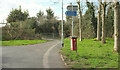
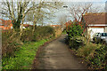
7
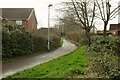
Rock Lane, Stoke Gifford
Carrying the Community Forest Path, and seen from where footpath LSG 7/10 meets it in the foreground (a path which, given the impressive list of destinations on the sign, is of some significance). Almost entirely obscured by trees along the lane is Greenwood, one of the few listed buildings in this area.
Image: © Derek Harper
Taken: 3 Mar 2020
0.09 miles
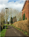
8
Path, Stoke Gifford
Footpath LSG 7/20 links Simmonds Way and Newbrick Road.
Image: © Derek Harper
Taken: 3 Mar 2020
0.10 miles
9
Path, Stoke Gifford
A reverse view of Image], showing footpath LSG 7/20. Just over the hedge on the right is the cul-de-sac shown in Image
Image: © Derek Harper
Taken: 3 Mar 2020
0.11 miles
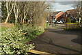
10
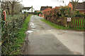
Cul-de-sac, Stoke Gifford
Off Rock Lane, and parallel to Image
Image: © Derek Harper
Taken: 3 Mar 2020
0.11 miles