IMAGES TAKEN NEAR TO
Westcourt Drive, BRISTOL, BS30 9SJ
Introduction
This page details the photographs taken nearby to Westcourt Drive, BS30 9SJ by members of the Geograph project.
The Geograph project started in 2005 with the aim of publishing, organising and preserving representative images for every square kilometre of Great Britain, Ireland and the Isle of Man.

There are currently over 7.5m images from over14,400 individuals and you can help contribute to the project by visiting https://www.geograph.org.uk
Image Map (Loading...)


Getting Data...Please wait
Leaflet Map data © OpenStreetMap
Images are licensed for reuse under creativecommons.org/licenses/by-sa/2.0
Notes
- Clicking on the map will re-center to the selected point.
- The higher the marker number, the further away the image location is from the centre of the postcode.
Image Listing (76 Images Found)
Images are licensed for reuse under creativecommons.org/licenses/by-sa/2.0
Image
Details
Distance
1
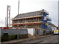
Unity Oldland Methodist Church
The old schoolroom, kitchen and vestry have been demolished, and major work on the body of the church is well underway; the ground is being prepared for an extension.
Image: © Neil Owen
Taken: 16 Feb 2017
0.09 miles
2
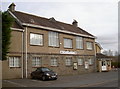
Oldland Village Club
The Oldland Common Village Hall, built in 1913 along with the church hall nearby. It was erected in response to the rapidly growing population in the late nineteenth and early twentieth centuries, largely due to coal mining and brass working.
Image: © Neil Owen
Taken: 16 Feb 2017
0.12 miles
3

West Hall Lodge
An interesting house along West Street, although perhaps not that old.
Image: © Neil Owen
Taken: 16 Feb 2017
0.12 miles
4
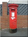
Old box in Oldland
The estates around here are largely post-war developments; a Georgian pillarbox stands on the corner of Westcourt Drive and Glenwood Drive - clearly a reuse from another spot. It is a product of the Carron Company of Stirlingsihre.
Image: © Neil Owen
Taken: 19 Jun 2021
0.12 miles
5
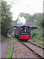
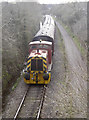
Avon Valley Railway near Oldland Common
Fry's Somerdale 4w Sentinel, No. 7492, passes beneath West Street bridge in Oldland Common on the Avon Valley Railway.
Image: © Gareth James
Taken: 16 Sep 2023
0.14 miles
6
The ?River Annan? from West Street bridge
The Avon Valley Railway has the run of the track along Oldland, albeit with just the three stations. Below the bridge is “River Annan” and is, according to the website:
'Ruston Hornsby 0-6-0DH NO.429
Pre TOPS number: 429 ‘River Annan’/’Salty’
Builder/Number: Ruston Hornsby (466618)
Built: 1961
This is a Ruston Hornsby LSSH 0-6-0DH (diesel hydraulic) shunting engine. Powered by a 275 hp Paxman 6RPHL 29-litre V6 engine, Twin Disc torque convertor and two-speed final drive, the LSSH is a capable short wheel base shunter, capable of handling heavy trains over short distances and tight curves.'
Image: © Neil Owen
Taken: 16 Feb 2017
0.14 miles
7
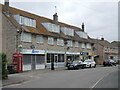
Shops on Westcourt Drive
Three-storey townhouses built along with the rest of the housing here are converted into shops. See Image] for a closer look at the telephone box to see if there is a phone in it.
Image: © Neil Owen
Taken: 19 Jun 2021
0.14 miles
8
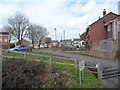
Houses on Meadow Court Drive, Oldland, Bristol
Seen from a north-bound train on the Avon Valley Railway.
Image: © Christine Johnstone
Taken: 27 Mar 2016
0.15 miles
9
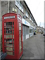
Phone box on Westcourt Drive
As with many, this box has been converted from the spoken word to the written word.
Image: © Neil Owen
Taken: 19 Jun 2021
0.15 miles
10

Avon Valley Railway near Oldland Common
Fry's Somerdale 4w Sentinel, No. 7492, approaches West Street bridge in Oldland Common on the Avon Valley Railway.
Image: © Gareth James
Taken: 16 Sep 2023
0.15 miles