IMAGES TAKEN NEAR TO
Cherry Garden Lane, BRISTOL, BS30 6PL
Introduction
This page details the photographs taken nearby to Cherry Garden Lane, BS30 6PL by members of the Geograph project.
The Geograph project started in 2005 with the aim of publishing, organising and preserving representative images for every square kilometre of Great Britain, Ireland and the Isle of Man.

There are currently over 7.5m images from over14,400 individuals and you can help contribute to the project by visiting https://www.geograph.org.uk
Image Map
Images are licensed for reuse under creativecommons.org/licenses/by-sa/2.0
Notes
- Clicking on the map will re-center to the selected point.
- The higher the marker number, the further away the image location is from the centre of the postcode.
Image Listing (88 Images Found)
Images are licensed for reuse under creativecommons.org/licenses/by-sa/2.0
Image
Details
Distance
1
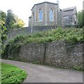
Retaining walls for the churchyard of St Anne's
Image: © William Avery
Taken: 23 Sep 2006
0.03 miles
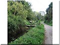
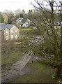
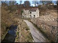
3
Siston Brook
The gentle stream runs down to Willsbridge Mill and then meets the Avon at Londonderry Farm.
Image: © Neil Owen
Taken: 16 Feb 2017
0.04 miles
4
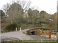
Bridge over Siston Brook
The brook forms a natural boundary for the imposing St Anne's church on the high ground beyond.
Image: © Neil Owen
Taken: 16 Feb 2017
0.04 miles
5
Looking down on the brook
Siston Brook as seen from the churchyard of St Anne's.
Image: © Neil Owen
Taken: 16 Feb 2017
0.04 miles
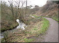
6
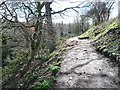
Path in Willsbridge Valley local nature reserve
High above Siston Brook.
Image: © Christine Johnstone
Taken: 27 Mar 2016
0.04 miles
7
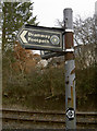
The Dramway Path
The Dramway is the local name for the Avon and Gloucestershire Railway that carried coal from the Coalpit Heath collieries. It opened in the late 1830s as a horse-drawn line, but was one of the country's last as steam had made its appearance and would soon overtake the horse. The line was primarily a gravity-powered tramway for most of its length, with empty wagons being pulled back up by full ones. The line closed in the late 1860s.
The Dramway Path is now a nine mile (15km) linear walk that follows sections of the route. The coalfields of northeast Bristol were linked by this route along the Siston Brook to wharf on the River Avon.
Image: © Neil Owen
Taken: 16 Feb 2017
0.04 miles
8
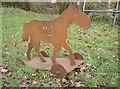
An iron horse
This little signpost to Cadbury Heath seems to emulate a child's toy.
Image: © Neil Owen
Taken: 16 Feb 2017
0.05 miles
9
Ruined house by the Siston Brook
Number 46, School Road, looks to be in the middle of demolition. Taken looking up the brook, in its steep-sided valley, from a footbridge between School Road and California Road.
Image: © Derek Harper
Taken: 9 Mar 2010
0.05 miles
10
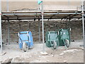
Barrows at rest
Work is underway to secure the steep earthen grounds of St Ann's church. The stone wall is having to be given extra support.
Image: © Neil Owen
Taken: 19 Jun 2021
0.06 miles