IMAGES TAKEN NEAR TO
Shepherds Way, WESTON-SUPER-MARE, BS22 7XP
Introduction
This page details the photographs taken nearby to Shepherds Way, BS22 7XP by members of the Geograph project.
The Geograph project started in 2005 with the aim of publishing, organising and preserving representative images for every square kilometre of Great Britain, Ireland and the Isle of Man.

There are currently over 7.5m images from over14,400 individuals and you can help contribute to the project by visiting https://www.geograph.org.uk
Image Map
Images are licensed for reuse under creativecommons.org/licenses/by-sa/2.0
Notes
- Clicking on the map will re-center to the selected point.
- The higher the marker number, the further away the image location is from the centre of the postcode.
Image Listing (87 Images Found)
Images are licensed for reuse under creativecommons.org/licenses/by-sa/2.0
Image
Details
Distance
1
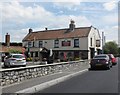
The Woolpack Inn, St Georges
This is a 17th century coaching inn, on the old Bristol - Weston road.
Image: © Rosalind Ashworth
Taken: 31 Mar 2007
0.02 miles
3
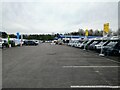
Davan Caravans
Davan Caravans is a caravan dealer on Shepherds Way in St Georges. It was built in 1982 on former farmland.
Image: © s
Taken: 9 Apr 2023
0.04 miles
4
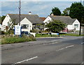
Welcome to St Georges, North Somerset
Viewed along Bristol Road at the corner of Shepherds Way. St Georges is a civil parish and village in North Somerset, adjacent to Weston-super-Mare. The parish is a modern creation, having formerly been part of the parish of Banwell.
Image: © Jaggery
Taken: 23 Jul 2011
0.05 miles
5
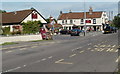
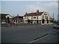
The Woolpack Inn, Worle
Located on Shepherds Way, St. Georges, Worle, at the SE edge of Weston-super-Mare.
The former uses of the Woolpack include a 17th century coaching house, and a wool packing station which served local farmers by baling wool for the northern mills.
Currently, the part of the premises at the left edge of the view is The Stable bar and carvery. The section farther away is the pub.
Image: © Jaggery
Taken: 23 Jul 2011
0.05 miles
6
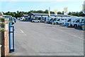
Davan Caravan Ltd, St Georges
Caravan and motor home premises viewed from Bristol Road.
Established in 1936 by Bert Davies, Davan is still owned and run by the Davies family.
Image: © Jaggery
Taken: 23 Jul 2011
0.05 miles
7
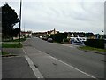
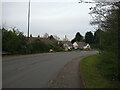
Shepherds Way looking East
The white building on the left in the background is the Woolpack Inn, which first appears on the 1844 Ordnance Survey Map. On the right is Davan Caravans which was built in 1982. Behind that are houses that were built in 2003 on a former orchard.
Image: © s
Taken: 9 Apr 2023
0.05 miles
8
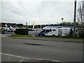
Davan Caravans
Davan Caravans is a caravan dealer on Shepherds Way in St Georges. It was built in 1982 on former farmland.
Image: © s
Taken: 9 Apr 2023
0.05 miles
9
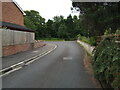
Shepherds Way looking Northeast
This section of Shepherds Way was built in 1973, along with the motorway junction. The original route of this road is now covered with trees to the left. This road used to be the A370 until 1973.
Image: © s
Taken: 9 Apr 2023
0.06 miles