IMAGES TAKEN NEAR TO
Strode Road, CLEVEDON, BS21 6QF
Introduction
This page details the photographs taken nearby to Strode Road, BS21 6QF by members of the Geograph project.
The Geograph project started in 2005 with the aim of publishing, organising and preserving representative images for every square kilometre of Great Britain, Ireland and the Isle of Man.

There are currently over 7.5m images from over14,400 individuals and you can help contribute to the project by visiting https://www.geograph.org.uk
Image Map
Images are licensed for reuse under creativecommons.org/licenses/by-sa/2.0
Notes
- Clicking on the map will re-center to the selected point.
- The higher the marker number, the further away the image location is from the centre of the postcode.
Image Listing (31 Images Found)
Images are licensed for reuse under creativecommons.org/licenses/by-sa/2.0
Image
Details
Distance
1
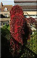
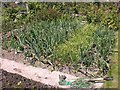
Virginia creeper by the Land Yeo
This specimen of Parthenocissus quinquefolia is visible in Image
Image: © Derek Harper
Taken: 22 Sep 2017
0.04 miles
2
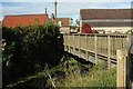
Bridge over Land Yeo at Clevedon
Footpath LA22 62/10 crosses this footbridge at the far side of the open space shown in Image] to reach Strode Road. See also Image
Image: © Derek Harper
Taken: 22 Sep 2017
0.04 miles
3
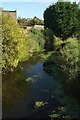
Land Yeo at Clevedon
Looking upstream (right) from the footbridge shown in Image The Land Yeo used to power numerous mills along its course, at least two of them in Clevedon https://en.wikipedia.org/wiki/Land_Yeo#Mills .
Image: © Derek Harper
Taken: 22 Sep 2017
0.04 miles
4
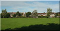
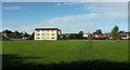
Recreation ground, Clevedon
Looking to the right from where Image] was taken, towards housing on Strode Road. The Land Yeo runs along the far edge of the green space. Footpath LA22 63/10 runs across the image as well.
Image: © Derek Harper
Taken: 22 Sep 2017
0.05 miles
5
Recreation ground, Clevedon
This public open space has been identified as having potential for residential or employment use https://www.n-somerset.gov.uk/wp-content/uploads/2015/11/Clevedon-site-appraisals.pdf . The space is crossed by footpath LA22 62/10, in the direction of the camera, to a bridge across the Land Yeo on the far side. It's also crossed by a footpath from left to right.
The block of 12 flats is Bees House.
Image: © Derek Harper
Taken: 22 Sep 2017
0.06 miles
6
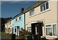
Houses on Westbourne Avenue, Clevedon
A terrace of four on a road that twists and turns.
Image: © Derek Harper
Taken: 22 Sep 2017
0.08 miles
7
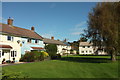
Houses on Westbourne Avenue, Clevedon
Looking the other way from where Image] was taken, with other terraces set back from the road behind lawns and trees.
Image: © Derek Harper
Taken: 22 Sep 2017
0.09 miles
8
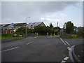
Traffic calming,Strode Road
A pinch point on the bridge over the Land Yeo
Image: © Anthony Vosper
Taken: 1 Sep 2015
0.09 miles
9
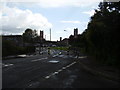
Traffic calming Strode Road
A pinch point on the bridge over the Land Yeo.
Image: © Anthony Vosper
Taken: 1 Sep 2015
0.09 miles