IMAGES TAKEN NEAR TO
Barleyfields, BRISTOL, BS2 0NA
Introduction
This page details the photographs taken nearby to Barleyfields, BS2 0NA by members of the Geograph project.
The Geograph project started in 2005 with the aim of publishing, organising and preserving representative images for every square kilometre of Great Britain, Ireland and the Isle of Man.

There are currently over 7.5m images from over14,400 individuals and you can help contribute to the project by visiting https://www.geograph.org.uk
Image Map
Images are licensed for reuse under creativecommons.org/licenses/by-sa/2.0
Notes
- Clicking on the map will re-center to the selected point.
- The higher the marker number, the further away the image location is from the centre of the postcode.
Image Listing (481 Images Found)
Images are licensed for reuse under creativecommons.org/licenses/by-sa/2.0
Image
Details
Distance
1
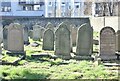
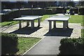
Jewish Cemetery (Closed)
Burials here date from 1762 to 1944. The gravestone inscriptions are in Hebrew script.
Image: © Anthony O'Neil
Taken: 28 Feb 2021
0.02 miles
2
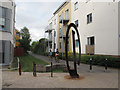
Bristol and Bath Railway Path at Barton Road
This section of the route is a link from the main National Cycle Route 4 to Bristol Temple Meads station, and uses the alignment of a former dock railway.
Image: © Stephen Craven
Taken: 24 Jun 2017
0.02 miles
3
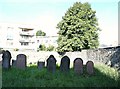
Barton Road, St Philip's, Bristol 2
This gated-and-locked Jewish cemetery is obliquely opposite the Barley Mow pub. Its establishment in the 1740s makes it the first in Bristol following the return of Jews to England following their expulsion of 1290. The earliest grave is dated 1762 and the most recent one in 1944. Bristol is one of the oldest provincial Jewish communities in the UK with records of a Jewish community dating back to the C12th and C13th. Because of the restrictions on Jews owning land it was leased for a number of years, finally being acquired by the Bristol Jewish Community in 1859. There are approximately 160 graves. The houses in the distance are in Sweetman Place.
Image: © David Hallam-Jones
Taken: 13 Aug 2017
0.03 miles
4
Bristol & Bath Railway Path, The Dings
The Bristol and Bath Railway Path which follows the old Midland Railway route between the two cities starts here from Barton Road in The Dings area of Bristol.
Image: © Stephen McKay
Taken: 10 Nov 2010
0.03 miles
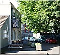
5
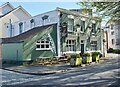
The Barley Mow, The Dings
Although only a short walk from Temple Meads station, this back street pub on Barton Road seems to occupy a different world on the far side of the Floating Harbour.
Image: © Stephen McKay
Taken: 10 Nov 2010
0.04 miles
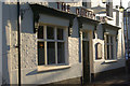
7
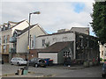
The Barley Mow pub, Barton Road
An unusually rustic name for a city pub.
Image: © Stephen Craven
Taken: 24 Jun 2017
0.04 miles
8
Barton Road, St Philip's, Bristol 2
Although in the past there were many pubs in The Ding neighbourhood in the past, “The Barley Mow” (a mow meaning ‘a stack’) is the only one remaining. It dates from the C19th and was previously known as “The Duke of York”. Opposite it is a playing field associated with the Hannah More Primary School.
Image: © David Hallam-Jones
Taken: 13 Aug 2017
0.05 miles
10
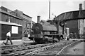
Saddletank shunting at Avon Street
Ex L&R 0-4-0ST 51221 shunting at Avon street. The railway is no longer in existence at this point
Image: © John Firth
Taken: Unknown
0.05 miles