IMAGES TAKEN NEAR TO
Kent Mews, BRISTOL, BS16 1WU
Introduction
This page details the photographs taken nearby to Kent Mews, BS16 1WU by members of the Geograph project.
The Geograph project started in 2005 with the aim of publishing, organising and preserving representative images for every square kilometre of Great Britain, Ireland and the Isle of Man.

There are currently over 7.5m images from over14,400 individuals and you can help contribute to the project by visiting https://www.geograph.org.uk
Image Map (Loading...)


Getting Data...Please wait
Leaflet Map data © OpenStreetMap
Images are licensed for reuse under creativecommons.org/licenses/by-sa/2.0
Notes
- Clicking on the map will re-center to the selected point.
- The higher the marker number, the further away the image location is from the centre of the postcode.
Image Listing (36 Images Found)
Images are licensed for reuse under creativecommons.org/licenses/by-sa/2.0
Image
Details
Distance
1
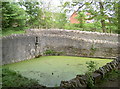
Before the days of hand car washes
This pond is said to have been used to wash farm carts back in the days when this estate was in private hands. It also provided water to other parts of the grounds.
Image: © Neil Owen
Taken: 13 May 2016
0.04 miles
2
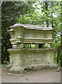
Enclosed memorial
This stone memorial has the Latin inscription 'Fraterni Dignus Amoris', which translates as 'Worthy of brotherly love'. Sadly, frost damage is starting to eat away at the legend.
Image: © Neil Owen
Taken: 13 May 2016
0.06 miles
3
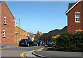
2011 : Trellick Way, near Harry Stoke
A modern development near the University of West of England.
Image: © Maurice Pullin
Taken: 2 May 2011
0.08 miles
4
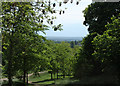
2011 : View south from Jellicoe Avenue
Open parkland with trees looking south over east Bristol though it is well hidden. Dundry Hill is in the distance.
Image: © Maurice Pullin
Taken: 2 May 2011
0.09 miles
5
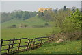
The Dower House. Stoke Park, Bristol
Now luxury flats, the Dower House is on the edge of the new housing development of Stoke Park which is just outside the Bristol City boundary into South Gloucestershire. The M32 Motorway into Bristol is in a cutting, not clearly shown on the OS Map, through the middle of this photo.
Image: © John Phillips
Taken: 15 Apr 2007
0.11 miles
6
Below the Dower House
The unusually coloured house on the path through Stoke Park.
Image: © George Evans
Taken: 13 Mar 2009
0.13 miles
7

The Dower House
A view of the Dower House from the northeast.
Image: © Brett Norris
Taken: 17 Aug 2009
0.14 miles
8
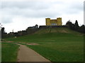
Elizabeth's monument and the big house
View over the former Stoke Park estate, featuring the (Dower) house and the monument to Elizabeth on Star Hill. See Image] for the small memorial.
Image: © Neil Owen
Taken: 13 May 2016
0.14 miles
9
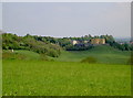
Dower House and the landscape
Today, this Grade II listed estate has the M32 for company. But in the past the grounds were extensive and the earth banking created for the house to stand on. Lower down in the grasslands were the original pond and a sports ground dating from the twentieth century.
Image: © Neil Owen
Taken: 13 May 2016
0.14 miles
10
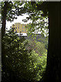
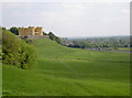
Dower House through the trees
Once this impressive estate house was owned by the Berkeley and Beaufort families; they had a lot of the surrounding downland landscaped, but by the twentieth century it had largely become unkempt. Responsibility having been given to Bristol City council, some of the features have been rediscovered.
Image: © Neil Owen
Taken: 13 May 2016
0.14 miles