IMAGES TAKEN NEAR TO
Fisher Road, BRISTOL, BS15 4RQ
Introduction
This page details the photographs taken nearby to Fisher Road, BS15 4RQ by members of the Geograph project.
The Geograph project started in 2005 with the aim of publishing, organising and preserving representative images for every square kilometre of Great Britain, Ireland and the Isle of Man.

There are currently over 7.5m images from over14,400 individuals and you can help contribute to the project by visiting https://www.geograph.org.uk
Image Map
Images are licensed for reuse under creativecommons.org/licenses/by-sa/2.0
Notes
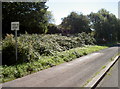
- Clicking on the map will re-center to the selected point.
- The higher the marker number, the further away the image location is from the centre of the postcode.
Image Listing (31 Images Found)
Images are licensed for reuse under creativecommons.org/licenses/by-sa/2.0
Image
Details
Distance
1
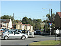
2009 : Urban into rural, New Cheltenham to Siston Common
Nearly at the point where east Bristol's sprawling housing estates become open countryside. (Officially this is Gloucestershire, the Bristol boundary is about a mile west of here.)
The roundabout to the right is at the eastern end of Cheltenham Road which gives way to Fisher Road on the other side.
Image: © Maurice Pullin
Taken: 12 Oct 2009
0.05 miles
2
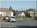
2009 : Roundabout at the end of Cheltenham Road
The eastern end, that is. New Cheltenham gives way to Siston Common on the other side of the roundabout as Cheltenham Road becomes Fisher Road.
Anchor Road is to the left and Tenniscourt Road to the right. Both of these roads were named after public houses (or vice versa).
Image: © Maurice Pullin
Taken: 12 Oct 2009
0.05 miles
3
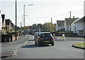
2009 : Tenniscourt Road, New Cheltenham
Leads to the A420 near the bottom of Warmley Hill.
Image: © Maurice Pullin
Taken: 12 Oct 2009
0.06 miles
4
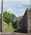
Path to Felicity Park
From Anchor Road, and running past Image] on the left.
Image: © Derek Harper
Taken: 29 May 2015
0.07 miles
5
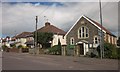
Made-for-Ever church, Kingswood
This 1896 Wesleyan Methodist church on Anchor Road shares a name with the nearby pub shown in Image From http://churchdb.gukutils.org.uk/GLS1401.php : "According to the Wordsworth Dictionary of Pub Names, by David Rothwell, "this area is known locally as 'Made for ever' because of a remark made by two miners, Lewis and Fudge, who discovered a huge deposit of coal and exclaimed 'We're made for ever' " ".
Image: © Derek Harper
Taken: 29 May 2015
0.08 miles
6
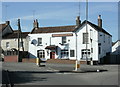
2009 : Anchor Made for Ever, New Cheltenham
Well, for the time being anyway.
Was unsure if they were still open but they are on a real ale website.
"250-year old two-bar pub, rumoured to have a residential ghost. Name came from
coal miners who thought they would be 'made forever' financially. Bass direct
from the cellar in summer."
The above was copied from:http://www.cauchy.demon.co.uk/raig/guide/ZKINGSWO.HTM
Image: © Maurice Pullin
Taken: 12 Oct 2009
0.09 miles
7
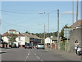
2009 : Anchor Road, on the edge of New Cheltenham
Heading north toward Station Road and the Avon Ring Road.
Image: © Maurice Pullin
Taken: 12 Oct 2009
0.11 miles
8
Beware of camouflaged cows
They're there, but you can't see them!
Image: © Neil Owen
Taken: 26 Sep 2018
0.13 miles
9
A prickly passing place
The narrow single carriageway road on Siston Common needs a little better for motorists! No problem for a tractor, though.
Image: © Neil Owen
Taken: 26 Sep 2018
0.13 miles
10
The old route of the Dramway
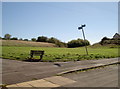
This open patch of land seems a rather uninspiring place for a bench seat, being in a rather quiet and unremarkable part of Siston Common. However, just beyond it was the route of the old Dramway - a horse-drawn railway line linking the local collieries with the River Avon to the south.
Image: © Neil Owen
Taken: 26 Sep 2018
0.13 miles