IMAGES TAKEN NEAR TO
Mellent Avenue, BRISTOL, BS13 0NT
Introduction
This page details the photographs taken nearby to Mellent Avenue, BS13 0NT by members of the Geograph project.
The Geograph project started in 2005 with the aim of publishing, organising and preserving representative images for every square kilometre of Great Britain, Ireland and the Isle of Man.

There are currently over 7.5m images from over14,400 individuals and you can help contribute to the project by visiting https://www.geograph.org.uk
Image Map
Images are licensed for reuse under creativecommons.org/licenses/by-sa/2.0
Notes
- Clicking on the map will re-center to the selected point.
- The higher the marker number, the further away the image location is from the centre of the postcode.
Image Listing (4 Images Found)
Images are licensed for reuse under creativecommons.org/licenses/by-sa/2.0
Image
Details
Distance
1
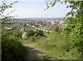
Close to the suburban fringe
Dundry rises high over the southern extents of Bristol. With a short walk uphill, the city becomes more distant pretty quickly and a green wilderness welcomes the hardy.
Image: © Neil Owen
Taken: 9 May 2017
0.13 miles
2
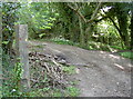
Malago marker
Up on the slopes to the north of East Dundry are the various issues and sources that collectively form the Malago and Pigeonhouse streams. The marker indicates a number of short tracks in the woodlands.
Image: © Neil Owen
Taken: 9 May 2017
0.20 miles
3
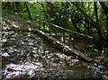
Malago marsh
The Malago rises on the slopes above Withywood; here the marshy ground has a wooden bridge to span the worst section.
Image: © Neil Owen
Taken: 9 May 2017
0.20 miles
4
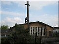
St Andrew, Hartcliffe
Parish Church in Hartcliffe.
Image: © don cload
Taken: 12 Apr 2009
0.23 miles