IMAGES TAKEN NEAR TO
Portway, BRISTOL, BS11 9QQ
Introduction
This page details the photographs taken nearby to Portway, BS11 9QQ by members of the Geograph project.
The Geograph project started in 2005 with the aim of publishing, organising and preserving representative images for every square kilometre of Great Britain, Ireland and the Isle of Man.

There are currently over 7.5m images from over14,400 individuals and you can help contribute to the project by visiting https://www.geograph.org.uk
Image Map
Images are licensed for reuse under creativecommons.org/licenses/by-sa/2.0
Notes
- Clicking on the map will re-center to the selected point.
- The higher the marker number, the further away the image location is from the centre of the postcode.
Image Listing (57 Images Found)
Images are licensed for reuse under creativecommons.org/licenses/by-sa/2.0
Image
Details
Distance
1
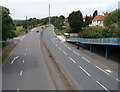
The Portway west of a footbridge, Shirehampton, Bristol
The Portway (the A4) viewed from this footbridge. http://www.geograph.org.uk/photo/3281129
Image: © Jaggery
Taken: 23 Jun 2012
0.12 miles
2
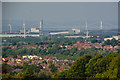
Wraxall and Failand : Pill Scenery
Looking from Wraxton and Failand across Pill and beyond with the Severn Crossing in view.
Image: © Lewis Clarke
Taken: 26 Jun 2020
0.13 miles
3
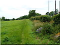
Track through The Daisy Field, Lamplighters Marsh, Shirehampton, Bristol
Viewed from the edge of Station Road, where an information board states that The Daisy Field is managed by Bristol Parks working with Shirehampton Community Action Forum.
Image: © Jaggery
Taken: 23 Jun 2012
0.13 miles
5
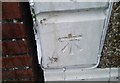
Ordnance Survey Cut Mark
This OS cut mark can be found on No59 Walton Road. It marks a point 30.020m above mean sea level.
Image: © Adrian Dust
Taken: 12 Mar 2020
0.15 miles
6
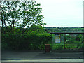
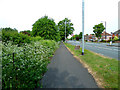
Shirehampton : Portway Bus Stop
A bus stop on the Portway Road.
Image: © Lewis Clarke
Taken: 30 May 2015
0.16 miles
8
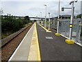
Portway Parkway railway station, Bristol
Opened in 2023 by Network Rail on the line from Bristol Temple Meads to Severn Beach, this single platform station cost £3.5 million.
View north west towards Avonmouth and Severn Beach. The M5 rather dominates the scene.
Image: © Nigel Thompson
Taken: 7 Aug 2023
0.18 miles
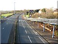
9
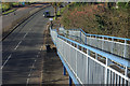
Portway, Shirehampton
Looking down from the footbridge which connects the two sections of Station Road for pedestrians, this is the A4 in the last couple of miles or so before it ends at Avonmouth.
Image: © Stephen McKay
Taken: 10 Nov 2010
0.19 miles
10
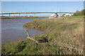
River Avon and Avonmouth Bridge
This view of the lower reaches of the River Avon was changed forever in 1974 when the Avonmouth Bridge, carrying the M5 between Gloucestershire and Somerset was opened.
Image: © Stephen McKay
Taken: 10 Nov 2010
0.19 miles