IMAGES TAKEN NEAR TO
Lower High Street, BRISTOL, BS11 0AY
Introduction
This page details the photographs taken nearby to Lower High Street, BS11 0AY by members of the Geograph project.
The Geograph project started in 2005 with the aim of publishing, organising and preserving representative images for every square kilometre of Great Britain, Ireland and the Isle of Man.

There are currently over 7.5m images from over14,400 individuals and you can help contribute to the project by visiting https://www.geograph.org.uk
Image Map
Images are licensed for reuse under creativecommons.org/licenses/by-sa/2.0
Notes
- Clicking on the map will re-center to the selected point.
- The higher the marker number, the further away the image location is from the centre of the postcode.
Image Listing (56 Images Found)
Images are licensed for reuse under creativecommons.org/licenses/by-sa/2.0
Image
Details
Distance
1
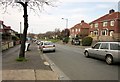
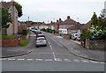
Lower High Street, Shirehampton
The Severn Way follows the B4054 - well, one of its pavements, I suppose - for some 350 metres downhill from this point.
Image: © Derek Harper
Taken: 29 Mar 2014
0.03 miles
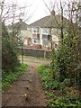
2
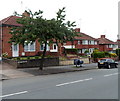
Lower High Street houses, Shirehampton, Bristol
Viewed from the corner of Penpole Lane.
The strange looking object between the tree and the car is a motorbike with a protective covering.
Image: © Jaggery
Taken: 23 Jun 2012
0.04 miles
3
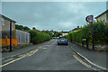
Shirehampton : Old Quarry Road
Looking along Old Quarry Road off Kings Weston Avenue.
Image: © Lewis Clarke
Taken: 8 Sep 2020
0.04 miles
4
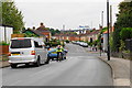
Crossroads in Shirehampton
Kings Weston Avenue meets Lower High Street. In the background, you can see the M5 as it crosses the River Avon.
Image: © Bill Boaden
Taken: 27 Sep 2017
0.05 miles
5
Old Park Road, Shirehampton, Bristol
Viewed across Lower High Street.
Image: © Jaggery
Taken: 23 Jun 2012
0.07 miles
6
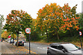
Autumn colours in Shirehampton
Lining Lower High Street.
Image: © Bill Boaden
Taken: 27 Sep 2017
0.07 miles
7
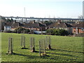
St Mary's Recreation Ground
A small pocket of greenery amid the houses, roads and industries. The park is also known as Beechley Walk.
Image: © Neil Owen
Taken: 6 Feb 2023
0.08 miles
8
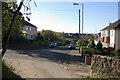
Penpole Lane, Shirehampton
Suburban housing on Penpole Lane seen from the foot of Penpole Wood.
Image: © Stephen McKay
Taken: 10 Nov 2010
0.09 miles
9
Severn Way at Penpole Lane
A reverse view of Image], with the Way following bridleway BCC/63/10 down a steep slope at the western end of Penpole Wood into suburban housing.
Image: © Derek Harper
Taken: 29 Mar 2014
0.09 miles
10
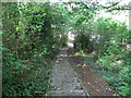
Steps down to Penpole Lane
From Penpole Point
Image: © Eirian Evans
Taken: 19 Sep 2017
0.09 miles