IMAGES TAKEN NEAR TO
Westacre Close, BRISTOL, BS10 7DQ
Introduction
This page details the photographs taken nearby to Westacre Close, BS10 7DQ by members of the Geograph project.
The Geograph project started in 2005 with the aim of publishing, organising and preserving representative images for every square kilometre of Great Britain, Ireland and the Isle of Man.

There are currently over 7.5m images from over14,400 individuals and you can help contribute to the project by visiting https://www.geograph.org.uk
Image Map
Images are licensed for reuse under creativecommons.org/licenses/by-sa/2.0
Notes
- Clicking on the map will re-center to the selected point.
- The higher the marker number, the further away the image location is from the centre of the postcode.
Image Listing (35 Images Found)
Images are licensed for reuse under creativecommons.org/licenses/by-sa/2.0
Image
Details
Distance
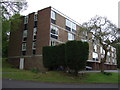
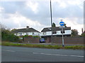
2
Westacre Close
These flats are on the north side of Westacre Close just off Brentry Hill, the A4018 running north out of Bristol between Westbury on Trym and Cribbs Causeway.
Image: © Nigel Mykura
Taken: 24 May 2010
0.02 miles
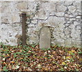
3
Old Boundary Marker on Passage Road, Henbury
Municipal Boundary Marker against a stone wall on the west side if the A4108 Passage Road in Henbury. On the boundary of Henbury and Westbury upon Trym parishes until 1904 when Westbury upon Trym became part of Bristol parish and borough. In 1935 this part of Henbury parish also became part of Bristol parish and borough. See also https://www.geograph.org.uk/photo/2151786.
Milestone Society National ID: GL_BRIS25pb
Image: © S Kosciow
Taken: 30 Apr 2022
0.04 miles
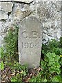
4
City Boundary 1904 stone, Bristol
In 1904, Shirehampton, Westbury on Trym and part of Henbury, all formerly in south Gloucestershire, became part of the City and County of Bristol. To mark the new city boundary in these places, stones with C.B. 1904 incised on them were installed. This one is on the west side of Passage Road, near to the turning for Westacre Close.
Image: © Jaggery
Taken: 6 Nov 2010
0.06 miles
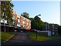
5
Houses on Brentry Hill
These houses are on Passage Rd or Brentry Hill on the A4018 dual carriageway into the centre of Bristol from Junction 17 of the M5 at Cribbs Causeway.
Image: © Nigel Mykura
Taken: 11 Nov 2012
0.07 miles
7
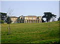
Brentry House
This building was designed by Humphry Repton for William Payne. It was built in 1802.
It is now used as the administration building for Brentry Hospital.
Image: © Linda Bailey
Taken: 2 Apr 2007
0.09 miles
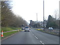
9
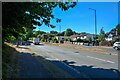
Bristol : Passage Road A4018
Looking along the road.
Image: © Lewis Clarke
Taken: 10 Aug 2022
0.11 miles
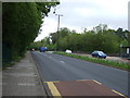
10
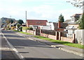
Dragons Well Road, Henbury, Bristol
Houses on the north side of the road, viewed from the Passage Road side.
English can be a wonderfully (or irritatingly) ambiguous language at times.
I wondered whether the road's name was a health bulletin concerning a mythical beast...
Image: © Jaggery
Taken: 6 Nov 2010
0.12 miles