IMAGES TAKEN NEAR TO
Ashbourne Rise, ORPINGTON, BR6 9PZ
Introduction
This page details the photographs taken nearby to Ashbourne Rise, BR6 9PZ by members of the Geograph project.
The Geograph project started in 2005 with the aim of publishing, organising and preserving representative images for every square kilometre of Great Britain, Ireland and the Isle of Man.

There are currently over 7.5m images from over14,400 individuals and you can help contribute to the project by visiting https://www.geograph.org.uk
Image Map
Images are licensed for reuse under creativecommons.org/licenses/by-sa/2.0
Notes
- Clicking on the map will re-center to the selected point.
- The higher the marker number, the further away the image location is from the centre of the postcode.
Image Listing (33 Images Found)
Images are licensed for reuse under creativecommons.org/licenses/by-sa/2.0
Image
Details
Distance
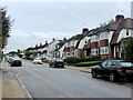
2
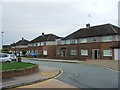
Ashbourne Rise
A road whose development started just before the Second World War and completed after it. It runs down to Tubbenden Lane.
Image: © Ian Capper
Taken: 21 Apr 2009
0.05 miles
4
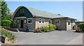
St Nicholas, Farnborough
Daughter church of St Giles the Abbot, Farnborough (see Image), built to serve the housing in the area that had been developed pre and post war. Work started in December 1957 and it was opened in June 1958. The structure was a prefabricated building from Rema Ltd of Salisbury. Initially known as the "New Church Hall", it was not named as St Nicholas's until 1967, to mark the 10th anniversary of the commencement of construction. The name was chosen partly because of St Nicholas's association with children, who made up a large proportion of the users of the building at the time, and also because St Nicholas's Day, 6 December, fell very close to the actual anniversary, 8 December!
Image: © Ian Capper
Taken: 8 Feb 2008
0.09 miles
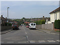
5
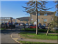
The Federation of Tubbenden Schools
Originally opened as Tubbenden Primary School in 1957, an increase in numbers led to a separation into two schools in 1963, one for Juniors and the other for Infants, with separate buildings on the same site. In 2004, events turned almost full circle, with a decision taken by the two schools to work more closely in a partnership known as a Federation. This photo shows the Tubbenden Lane entrance to the schools.
Post script:
In September 2009, the two schools once again merged to form a single Primary School. On 1 March 2012 the school became an Academy.
Image: © Ian Capper
Taken: 8 Feb 2008
0.09 miles
7
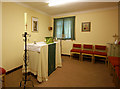
St Nicholas, Leamington Avenue, Farnborough, Kent - Chapel
Image: © John Salmon
Taken: 28 Jun 2010
0.11 miles
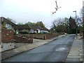
9
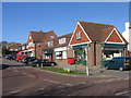
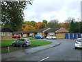
Shops in Tile Farm Road
A small group of local shops, including (at least in early 2008!) a post office. The road in the foreground is Tubbenden Lane, an old route from Orpington to Farnborough.
Image: © Ian Capper
Taken: 8 Feb 2008
0.12 miles
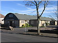
10
St Nicholas, Leamington Avenue, Farnborough, Kent
Image: © John Salmon
Taken: 28 Jun 2010
0.12 miles