IMAGES TAKEN NEAR TO
Sevenoaks Road, ORPINGTON, BR6 7LS
Introduction
This page details the photographs taken nearby to Sevenoaks Road, BR6 7LS by members of the Geograph project.
The Geograph project started in 2005 with the aim of publishing, organising and preserving representative images for every square kilometre of Great Britain, Ireland and the Isle of Man.

There are currently over 7.5m images from over14,400 individuals and you can help contribute to the project by visiting https://www.geograph.org.uk
Image Map
Images are licensed for reuse under creativecommons.org/licenses/by-sa/2.0
Notes
- Clicking on the map will re-center to the selected point.
- The higher the marker number, the further away the image location is from the centre of the postcode.
Image Listing (11 Images Found)
Images are licensed for reuse under creativecommons.org/licenses/by-sa/2.0
Image
Details
Distance
1
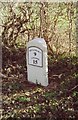
Old Milestone by the A21, Sevenoaks Road, Pratt's Bottom
Metal plate (replica) attached to stone post by the A21, in parish of ORPINGTON (BROMLEY District), Sevenoaks Road, East of Norsted Lane, Pratt's Bottom, on the verge beside hedge and large tree, on South side of road. Sevenoaks marker, erected by the Sevenoaks turnpike trust in the 19th century.
Inscription reads:-
SEVENOAKS
9
LONDON
15
(Mileages should be 8 and 16)
Carved benchmark on lower face.
Grade II listed.
List Entry Number: 1186828 https://historicengland.org.uk/listing/the-list/list-entry/1186828
Milestone Society National ID: KE_LR16.
Image: © C Woodward
Taken: 16 Mar 2007
0.03 miles
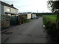
2
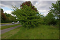
Sevenoaks Road, old and new
Some maps (including the 1:50,000 tile used on Geograph at the date of submission) still show a short loop running off Sevenoaks Road to the foot of Charmwood Lane - the 1948 and older 1 inch maps show the loop as the course of the main road, the current main road bypassing the loop being a subsequent development. However, other than a few patches of tarmac showing through the grass and shrub, there is now nothing to show for the western part of the loop, seen here on the right of the photo (the current road is visible on the left). The eastern stretch of the loop has now been incorporated in Charmwood Lane.
Image: © Ian Capper
Taken: 28 May 2010
0.08 miles
3
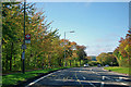
Charmwood Lane bus stop
On the A21 and served by routes 402 and R10.
Image: © Robin Webster
Taken: 27 Sep 2011
0.14 miles
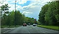
4
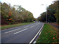
A21 Sevenoaks Road near Pratt's Bottom BR6
Looking east. The end of Charmwood Lane is on the right.
Image: © Philip Talmage
Taken: 7 Nov 2005
0.15 miles
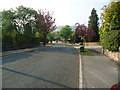
6
A21 Sevenoaks Road at the junction with Charmwood Lane
Image: © Christopher Hilton
Taken: 11 May 2023
0.18 miles
7
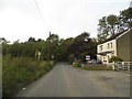
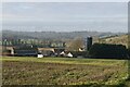
Charmwood Farm, Charmwood Lane BR6
Looking south
Image: © Philip Talmage
Taken: 7 Nov 2005
0.19 miles
10

Sevenoaks Road (A21) near Pratt's Bottom
Image: © Stacey Harris
Taken: 24 Apr 2011
0.21 miles