IMAGES TAKEN NEAR TO
Worlds End Lane, ORPINGTON, BR6 6AE
Introduction
This page details the photographs taken nearby to Worlds End Lane, BR6 6AE by members of the Geograph project.
The Geograph project started in 2005 with the aim of publishing, organising and preserving representative images for every square kilometre of Great Britain, Ireland and the Isle of Man.

There are currently over 7.5m images from over14,400 individuals and you can help contribute to the project by visiting https://www.geograph.org.uk
Image Map
Images are licensed for reuse under creativecommons.org/licenses/by-sa/2.0
Notes
- Clicking on the map will re-center to the selected point.
- The higher the marker number, the further away the image location is from the centre of the postcode.
Image Listing (137 Images Found)
Images are licensed for reuse under creativecommons.org/licenses/by-sa/2.0
Image
Details
Distance
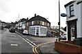
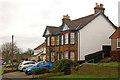
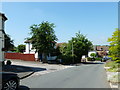
1
Worlds End Lane
Housing from around the turn of the 19th/20th centuries. The shop in the background, situated at the junction with Ash Road (see Image), was until the late 1960s a post office.
Image: © Ian Capper
Taken: 9 Dec 2009
0.01 miles
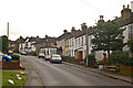
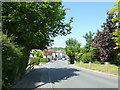
2
Worlds End Lane
Although the houses on the right hand side of Worlds End Lane clearly date from when the road was first developed, around the turn of the 19th/20th centuries, those on the other side is generally more recent. This pair of semidetached houses is an exception, though.
Image: © Ian Capper
Taken: 9 Dec 2009
0.01 miles

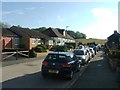
5
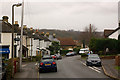
Worlds End Lane
Housing dating from around the turn of the 19th/20th centuries. On the left is what was the post office until the late 1960s. In the background is St Mary's Church (see Image).
Image: © Ian Capper
Taken: 9 Dec 2009
0.02 miles
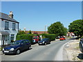
6
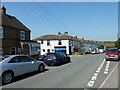
Approaching the junction of Ash Road, Farrant Close and Worlds End Lane
Image: © Basher Eyre
Taken: 4 Jun 2010
0.02 miles
7
Approaching the junction of Worlds End Lane and Elm Road
Image: © Basher Eyre
Taken: 4 Jun 2010
0.02 miles