IMAGES TAKEN NEAR TO
Novar Close, ORPINGTON, BR6 0XA
Introduction
This page details the photographs taken nearby to Novar Close, BR6 0XA by members of the Geograph project.
The Geograph project started in 2005 with the aim of publishing, organising and preserving representative images for every square kilometre of Great Britain, Ireland and the Isle of Man.

There are currently over 7.5m images from over14,400 individuals and you can help contribute to the project by visiting https://www.geograph.org.uk
Image Map
Images are licensed for reuse under creativecommons.org/licenses/by-sa/2.0
Notes
- Clicking on the map will re-center to the selected point.
- The higher the marker number, the further away the image location is from the centre of the postcode.
Image Listing (97 Images Found)
Images are licensed for reuse under creativecommons.org/licenses/by-sa/2.0
Image
Details
Distance
1
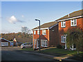
Housing diversity (Novar Close)
A series of photos showing the diversity of housing in one gridsquare in outer suburbia. For others in series see http://www.geograph.org.uk/search.php?i=1905481. Any further information, such as building dates and what was on the sites before building, would be appreciated.
Novar Close, like Sequoia Gardens (see Image]), a fill in on Broom Hill, off Irene Road, with a mixture of modern bungalows and detached houses.
Image: © Ian Capper
Taken: 23 Nov 2007
0.02 miles
2
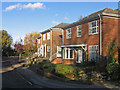
Housing diversity (Sequoia Gardens)
A series of photos showing the diversity of housing in one gridsquare in outer suburbia. For others in series see http://www.geograph.org.uk/search.php?i=1905481. Any further information, such as building dates and what was on the sites before building, would be appreciated.
Sequoia Gardens, a 1970s? fill in on Broom Hill, off Irene Close. It was built on what was originally a small patch of nursery garden between Irene Close and Broxbourne Road.
Image: © Ian Capper
Taken: 21 Nov 2007
0.07 miles
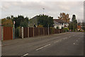
3
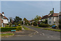
Broxbourne Road
Part of the inter-war development of the Knoll Rise/Broom Hill area. The route of the road (with no houses) is partially shown on the 1910 6 inch map, although this section, north of St Kilda Road, is absent. However full development is shown on the 1938 map (based on a 1930-31 revision).
Image: © Ian Capper
Taken: 24 Apr 2015
0.07 miles
4
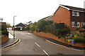
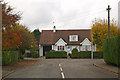
Corn Mill Drive
A short cul de sac built in the 1980s(?) of Broomhill Road. Despite the name and position on a hill, there is no sign of a mill on this site on old maps going back to 1868.
Image: © Ian Capper
Taken: 11 Nov 2009
0.08 miles
5
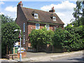
Housing diversity (Perry Hall Farmhouse, Chislehurst Road)
A series of photos showing the diversity of housing in one gridsquare in outer suburbia. For others in series see http://www.geograph.org.uk/search.php?i=1905481. Any further information, such as building dates and what was on the sites before building, would be appreciated.
In contrast to the 20th century development of this gridsquare, this grade II listed building (for listing particulars see www.historicengland.org.uk/listing/the-list/list-entry/1064329 ) is one of the oldest buildings in Orpington, having been built in the 18th century, being the farmhouse for the farm that covered part of this area. It is a reminder that there was life before suburban sprawl!
Image: © Ian Capper
Taken: 5 Jun 2008
0.08 miles
6
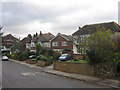
Housing diversity (Irene Road)
A series of photos showing the diversity of housing in one gridsquare in outer suburbia. For others in series see http://www.geograph.org.uk/search.php?i=1905481. Any further information, such as building dates and what was on the sites before building, would be appreciated.
This is Irene Road, built off Keswick Road in the second phase of development of the Knoll/Broom Hill area, first appearing on maps in 1930.
The footpath to the left of the house is one of a number of such paths in the area that predate its development for housing.
Image: © Ian Capper
Taken: 12 Nov 2009
0.08 miles
7
Housing diversity (Broxbourne Road)
A series of photos showing the diversity of housing in one gridsquare in outer suburbia. For others in series see http://www.geograph.org.uk/search.php?i=1905481. Any further information, such as building dates and what was on the sites before building, would be appreciated.
Broxbourne Road – part of the interwar development of the Broom Hill area.
Image: © Ian Capper
Taken: 23 Nov 2007
0.08 miles
8
Housing diversity (Chislehurst Road)
A series of photos showing the diversity of housing in one gridsquare in outer suburbia. For others in series see http://www.geograph.org.uk/search.php?i=1905481. Any further information, such as building dates and what was on the sites before building, would be appreciated.
Chislehurst Road, which as its name suggests was once the main Orpington to Chislehurst road, before this stretch was superseded in the 1970s (?) by Perry Hall Road, slightly further to the north. The original housing here appears to be pre war, with some subsequent in filling.
Image: © Ian Capper
Taken: 23 Nov 2007
0.09 miles
9
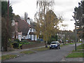
Irene Road
Looking towards its junction with Keswick Road with Cyril Road beyond.
The footpath is one of a network of footpaths in the Knoll area of Orpington, the routes of which are shown on the 1868 Godfrey edition map of Orpington, which explains why they cut across the current, much more recent, road layout. This one runs from Irene Road to Keswick Road, before continuing to Broomhill Road. It is the same as the one shown in Image, viewed from the opposite end.
Image: © Ian Capper
Taken: 12 Nov 2009
0.09 miles
10
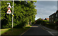
Broomhill Road - Steep Hill 11%
Broomhill Road, Orpington. 11% steep hill down sign.
Image: © Adam Morse
Taken: 5 Aug 2009
0.09 miles