IMAGES TAKEN NEAR TO
Corn Mill Drive, ORPINGTON, BR6 0TB
Introduction
This page details the photographs taken nearby to Corn Mill Drive, BR6 0TB by members of the Geograph project.
The Geograph project started in 2005 with the aim of publishing, organising and preserving representative images for every square kilometre of Great Britain, Ireland and the Isle of Man.

There are currently over 7.5m images from over14,400 individuals and you can help contribute to the project by visiting https://www.geograph.org.uk
Image Map
Images are licensed for reuse under creativecommons.org/licenses/by-sa/2.0
Notes
- Clicking on the map will re-center to the selected point.
- The higher the marker number, the further away the image location is from the centre of the postcode.
Image Listing (124 Images Found)
Images are licensed for reuse under creativecommons.org/licenses/by-sa/2.0
Image
Details
Distance
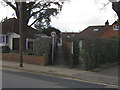
1
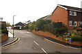
Corn Mill Drive
A short cul de sac built in the 1980s(?) of Broomhill Road. Despite the name and position on a hill, there is no sign of a mill on this site on old maps going back to 1868.
Image: © Ian Capper
Taken: 11 Nov 2009
0.03 miles
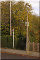
2
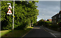
Broomhill Road - Steep Hill 11%
Broomhill Road, Orpington. 11% steep hill down sign.
Image: © Adam Morse
Taken: 5 Aug 2009
0.04 miles
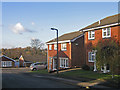
3
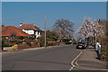
Keswick Road
Part of the Knoll area of Orpington, the layout of which was set out in around 1910.
Image: © Ian Capper
Taken: 15 Mar 2012
0.05 miles
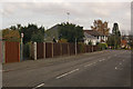
4
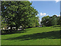
Broomhill Common
A triangle of open land between Chislehurst Road and Broomhill Road.
Image: © Ian Capper
Taken: 1 May 2009
0.05 miles
5
Footpath
One of a network of footpaths in the Knoll area of Orpington, the routes of which are shown on the 1868 Godfrey edition map of Orpington, which explains why they cut across the current, much more recent, road layout. This one runs from Keswick Road, across Irene Road before continuing to Broxbourne Road.
Image: © Ian Capper
Taken: 5 Mar 2009
0.06 miles
6
Footpath
One of a network of footpaths in the Knoll area of Orpington, the routes of which are shown on the 1868 Godfrey edition map of Orpington, which explains why they cut across the current, much more recent, road layout. This one runs from Keswick Road towards Broomhill Road. It is the continuation of the path in Image in the opposite direction.
Image: © Ian Capper
Taken: 12 Nov 2009
0.06 miles
7
Housing diversity (Novar Close)
A series of photos showing the diversity of housing in one gridsquare in outer suburbia. For others in series see http://www.geograph.org.uk/search.php?i=1905481. Any further information, such as building dates and what was on the sites before building, would be appreciated.
Novar Close, like Sequoia Gardens (see Image]), a fill in on Broom Hill, off Irene Road, with a mixture of modern bungalows and detached houses.
Image: © Ian Capper
Taken: 23 Nov 2007
0.07 miles
8
Irene Road
Looking towards its junction with Keswick Road with Cyril Road beyond.
The footpath is one of a network of footpaths in the Knoll area of Orpington, the routes of which are shown on the 1868 Godfrey edition map of Orpington, which explains why they cut across the current, much more recent, road layout. This one runs from Irene Road to Keswick Road, before continuing to Broomhill Road. It is the same as the one shown in Image, viewed from the opposite end.
Image: © Ian Capper
Taken: 12 Nov 2009
0.07 miles
9
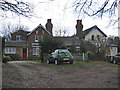
Cottages, Broom Hill
This range of cottages, with their ornate chimnneys, are shown on the 1868 Godfrey edition map of Orpington as one of a small group of cottages on Broom Hill.
Image: © Ian Capper
Taken: 5 Mar 2009
0.07 miles
10
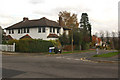
Junction of Keswick Road and Cyril Road
Part of the Knoll area of Orpington, the layout of which was set out in around 1910.
Image: © Ian Capper
Taken: 12 Nov 2009
0.08 miles