IMAGES TAKEN NEAR TO
Spur Road, ORPINGTON, BR6 0QR
Introduction
This page details the photographs taken nearby to Spur Road, BR6 0QR by members of the Geograph project.
The Geograph project started in 2005 with the aim of publishing, organising and preserving representative images for every square kilometre of Great Britain, Ireland and the Isle of Man.

There are currently over 7.5m images from over14,400 individuals and you can help contribute to the project by visiting https://www.geograph.org.uk
Image Map (Loading...)


Getting Data...Please wait
Leaflet Map data © OpenStreetMap
Images are licensed for reuse under creativecommons.org/licenses/by-sa/2.0
Notes
- Clicking on the map will re-center to the selected point.
- The higher the marker number, the further away the image location is from the centre of the postcode.
Image Listing (259 Images Found)
Images are licensed for reuse under creativecommons.org/licenses/by-sa/2.0
Image
Details
Distance
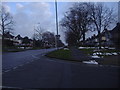
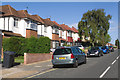
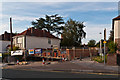
2
Spur Road
Spur Road was built in the 1920s to link the new Orpington Bypass with the southern end of High Street, by what is now the War Memorial roundabout. At the western end the housing is away from the main road in a separate service road, as here.
Image: © Ian Capper
Taken: 22 May 2012
0.05 miles
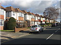
3
Spur Road
Built in the 1920s to link the new Orpington Bypass with the southern end of High Street, by what is now the War Memorial roundabout. Originally unnumbered, it now forms part of the A232 which runs across the outer suburbs of south London from here through Croydon and Sutton to Ewell.
Image: © Ian Capper
Taken: 18 Jul 2014
0.05 miles
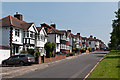
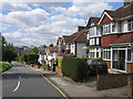
4
Lancing Road
One of the "public schools" roads in this part of Orpington. Note the standard prewar design of housing.
Image: © Ian Capper
Taken: 6 Feb 2008
0.06 miles
5
Lancing Road
One of the number of roads in this part of Orpington named after public schools.
Image: © Ian Capper
Taken: 15 Jul 2010
0.06 miles
6
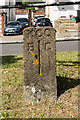
Boundary stone
What would seem to be a boundary stone, situated on Spur Road (see Image for wider view).
I have not been able to identify what it signifies. "KCC" is almost certainly "Kent County Council" (in which county this area was situated until included in the London Borough of Bromley in 1965). But the meaning of "B" and "C" is a mystery. From old maps there has never been a boundary here, and in the 1920s this would have all been part of the Bromley Rural District, before becoming Orpington Urban District in 1934. The village of Chelsfield lies to the southeast of here, but I can find no evidence of it having reached this far, and even if it did, that would leave the "B" totally unexplained - at this level west of here would unquestionably have been Orpington.
Image: © Ian Capper
Taken: 24 Jun 2015
0.06 miles
7

Spur Road
Spur Road was built in the 1920s to link the new Orpington Bypass with the southern end of High Street, by what is now the War Memorial roundabout. At the western end the housing is away from the main road in a separate service road, seen on the left here. In the foreground is the boundary stone in Image
Image: © Ian Capper
Taken: 24 Jun 2015
0.06 miles
8
Spur Road
Interwar semis built on a service road at the western end of Spur Road. In the background is the Tescos building opened in May 2009.
Image: © Ian Capper
Taken: 29 Apr 2009
0.07 miles
9
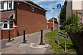
Mortimer Road
Mortimer Road was built in the 1970s or so to connect Lancing Road and Homefield Rise, replacing a house at this point in Lancing Road. At some point later it was blocked off (see Image), presumably because it was being used as a rat run to bypass the High Street. In 2010, it turned full circle, with a house built on the site (seen on the left of this photo).
Despite its status at the Lancing Road end only as a footpath, it still retains its street sign, as seen here.
Image: © Ian Capper
Taken: 17 Aug 2012
0.07 miles
10
Mortimer Road
Mortimer Road was built in the 1970s or so to connect Lancing Road and Homefield Rise, replacing a house at this point in Lancing Road. At some point later it was blocked off (see Image), presumably because it was being used as a rat run to bypass the High Street. In 2010, it turned full circle, with a house built on the site.
Here is the start of building (see also Image, Image and Image).
Image: © Ian Capper
Taken: 1 Sep 2010
0.07 miles