IMAGES TAKEN NEAR TO
High Street, ORPINGTON, BR6 0NQ
Introduction
This page details the photographs taken nearby to High Street, BR6 0NQ by members of the Geograph project.
The Geograph project started in 2005 with the aim of publishing, organising and preserving representative images for every square kilometre of Great Britain, Ireland and the Isle of Man.

There are currently over 7.5m images from over14,400 individuals and you can help contribute to the project by visiting https://www.geograph.org.uk
Image Map
Images are licensed for reuse under creativecommons.org/licenses/by-sa/2.0
Notes
- Clicking on the map will re-center to the selected point.
- The higher the marker number, the further away the image location is from the centre of the postcode.
Image Listing (354 Images Found)
Images are licensed for reuse under creativecommons.org/licenses/by-sa/2.0
Image
Details
Distance
1
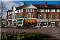
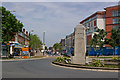
High Street
The southernmost section of Central Parade, dating from around 1932, at the point where High Street ends at the War Memorial roundabout.
Image: © Ian Capper
Taken: 10 Feb 2012
0.01 miles

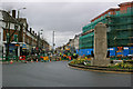
3
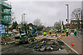
Orpington High Street improvement
Work underway the Orpington High Street Improvement scheme (see below).
Although initial work was on the pavements, late March/early April saw the southern end of the High Street closed to traffic for work on the roadway itself. Here is the southern end of the closure, near the War Memorial, showing a new raised zebra crossing.
Image: © Ian Capper
Taken: 31 Mar 2010
0.01 miles
4

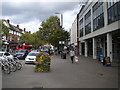
Orpington
Looking along the High Street, in a northerly direction.
Image: © Peter Trimming
Taken: 9 Jul 2024
0.02 miles
5
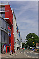
Wide pavement along High Street, Orpington
Image: © Richard Vince
Taken: 28 Sep 2019
0.02 miles

7
Augustus Lane
Looking up Augustus Lane from across Station Road, with the entrance to Tescos on the left.
Image: © Ian Capper
Taken: 23 Jun 2010
0.02 miles
8
War Memorial Roundabout
The War Memorial Roundabout is situated at the south end of High Street, at its junction with Station Road, Spur Road and Sevenoaks Road. The War Memorial itself, designed by local architect Charles Heaton Comyn and unveiled in 1921, is grade II listed - for listing particulars see www.historicengland.org.uk/listing/the-list/list-entry/1391943.
Image: © Ian Capper
Taken: 23 Jun 2010
0.02 miles
9
Orpington High Street improvement
Work underway the Orpington High Street Improvement scheme (see below).
Although initial work was on the pavements, late March/early April saw the southern end of the High Street closed to traffic for work on the roadway itself. This photo shows the southern end of the closure, at the War Memorial roundabout, with the new Orpington Village Hall being built on the right.
Image: © Ian Capper
Taken: 31 Mar 2010
0.02 miles
10
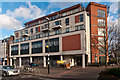
Orpington Village Hall
The original Village Hall was built in 1890 to a design of local architect George St Pierre Harris, when Orpington was indeed just a village. It contained a 350 seat concert hall, a billiard room, library and small committee rooms. Other than during the two World Wars, when it served as a hospital, muster point and refuge centre, it continued to provide a social focus for the growing town until the 1960s. For a couple of years from 1927 it was used by the local Presbyterian Church for services, prior to their moving to their permanent site on Knoll Rise, where they built St John's Church (see Image). However, in 1962, the Village Hall was badly damaged by fire, and following neglect over the years, it was eventually demolished in the late 1970s.
Work started on a replacement building in 1981, and this was opened the following year, still known as the Village Hall. It contained a single hall on the ground floor with further rooms on the first floor. For a photo, see Image This building lasted 26 years, before being demolished in 2008.
Its replacement, opened in October 2010, is a much larger building, which retains the original name. It contains two halls and a small conference room on the second floor. The larger of the two halls is named after Alfred Brown, who had funded the original Village Hall, the smaller hall is named after Aubrey Mullock, an Orpington estate agent who was the driving force behind much of the development of the town in the inter-war years as well as a number of community organisations, while the conference room is named after Frank Whymark, who had ensured the eventual replacement of the original Hall by the 1982 building. The top three floors contain 19 apartments.
When opened in 2010, the ground floor, intended to house a restaurant, remained vacant. Here, two years later, there is sign of development, although it subsequently became clear that only a small part of the ground floor was going to be used - see Image For a previous view see Image
Image: © Ian Capper
Taken: 22 Nov 2012
0.02 miles