IMAGES TAKEN NEAR TO
Perry Hall Road, ORPINGTON, BR6 0EF
Introduction
This page details the photographs taken nearby to Perry Hall Road, BR6 0EF by members of the Geograph project.
The Geograph project started in 2005 with the aim of publishing, organising and preserving representative images for every square kilometre of Great Britain, Ireland and the Isle of Man.

There are currently over 7.5m images from over14,400 individuals and you can help contribute to the project by visiting https://www.geograph.org.uk
Image Map
Images are licensed for reuse under creativecommons.org/licenses/by-sa/2.0
Notes
- Clicking on the map will re-center to the selected point.
- The higher the marker number, the further away the image location is from the centre of the postcode.
Image Listing (85 Images Found)
Images are licensed for reuse under creativecommons.org/licenses/by-sa/2.0
Image
Details
Distance
1
Nursery Close
A cul-de-sac developed in the 1950s off Sandy Lane, built on the site of what was marked on maps from 1930 to 1950 as a nursery.
Image: © Ian Capper
Taken: 11 Nov 2009
0.05 miles
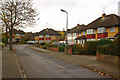
2
Perry Hall Road
A stretch of Perry Hall Road dating from the 1970s - the houses themselves were earlier (1950s/60s) on what maps suggest was a track connecting Footbury Hill Road with Mountview Road and the ends of Sandy Lane and Cambrai Road.
Image: © Ian Capper
Taken: 3 Feb 2012
0.05 miles
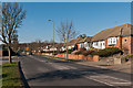
3
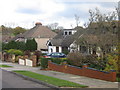
Sandy Lane
A road linking Perry Hall Road and Chislehurst Road. It was laid out in the 1930s as a cul-de-sac (at that stage Perry Hall Road, in the foreground, had not been built) with the houses visible on the left hand side of the photo being built. The right hand side was marked on maps from 1930 to 1950 as a nursery, suggesting that this side of the road was not developed until the 1950s.
Image: © Ian Capper
Taken: 11 Nov 2009
0.06 miles
4
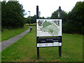
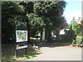
Entrance to Poverest Recreation Ground and Covet Wood
This very clear information board makes it hard to become lost. It is located at the approach from Perry Hall Road. Half of the open space is devoted to Poverest Recreation Ground whilst the north-western half is Covet Wood.
Image: © Marathon
Taken: 5 Aug 2011
0.07 miles
5
Housing diversity (Cambray Road)
A series of photos showing the diversity of housing in one gridsquare in outer suburbia. For others in series see http://www.geograph.org.uk/search.php?i=1905481. Any further information, such as building dates and what was on the sites before building, would be appreciated.
Cambray Road, which the 1940 1 inch map at http://www.npemap.org.uk/tiles/map.html#546,166,1 shows as a close off Chislehurst Road, with the 1970 1 inch map showing as having an extension at the foot along the line of the current Perry Hall Road, which since then has been widened to form a replacement main A208 Orpington to Chislehurst road, with Cambray Road forming a link between the old and new roads.
Image: © Ian Capper
Taken: 23 Nov 2007
0.07 miles
6

Entrance to Poverest Park from Perry Hall Road
Image: © Ian Capper
Taken: 29 Jan 2008
0.07 miles
7
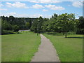
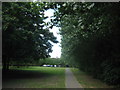
Footpath in Poverest Park
This path leads downhill from the sports pavilion within the park towards Perry Hall Road.
Compare with Image
Image: © David Anstiss
Taken: 24 Jul 2011
0.08 miles
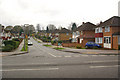
8
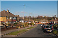
Sandy Lane
A road linking Perry Hall Road and Chislehurst Road. It was laid out in the 1930s as a cul-de-sac (at that stage Perry Hall Road, in the background, had not been built) with the houses visible on the right hand side of the photo being built. The left hand side was marked on maps from 1930 to 1950 as a nursery, suggesting that this side of the road was not developed until the 1950s.
Image: © Ian Capper
Taken: 3 Feb 2012
0.09 miles
9
Footpath junction in Poverest Park
A byway from Footbury Hill Road, leads into a footpath to Chislehurst Road, past a sports pavilion. Another path leads right towards Lockesley Road or left to Perry Hall Road.
In the foreground is a large information board about the park.
Image: © David Anstiss
Taken: 24 Jul 2011
0.09 miles
10
Footpath to Poverest Park
A path leads from Footbury Hill Road, beside a byway (used as an access road to a car park for the park).
Image: © David Anstiss
Taken: 24 Jul 2011
0.10 miles