IMAGES TAKEN NEAR TO
Lamberhurst Close, ORPINGTON, BR5 4QQ
Introduction
This page details the photographs taken nearby to Lamberhurst Close, BR5 4QQ by members of the Geograph project.
The Geograph project started in 2005 with the aim of publishing, organising and preserving representative images for every square kilometre of Great Britain, Ireland and the Isle of Man.

There are currently over 7.5m images from over14,400 individuals and you can help contribute to the project by visiting https://www.geograph.org.uk
Image Map
Images are licensed for reuse under creativecommons.org/licenses/by-sa/2.0
Notes
- Clicking on the map will re-center to the selected point.
- The higher the marker number, the further away the image location is from the centre of the postcode.
Image Listing (78 Images Found)
Images are licensed for reuse under creativecommons.org/licenses/by-sa/2.0
Image
Details
Distance
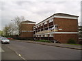
1
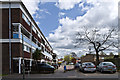
Peckham House
One of a number of similar blocks on the Ramsden Estate, this one built in 1969. Beyond it on the left is part of another, Lenham House.
Image: © Ian Capper
Taken: 29 Apr 2013
0.01 miles
2
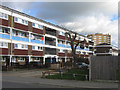
Peckham House
One of the blocks on the Ramsden Estate, this one built in 1969, with the Bekesbourne Tower (one of three such towers on the estate, this one also dating from 1969) in the background.
Image: © Ian Capper
Taken: 6 Feb 2008
0.01 miles
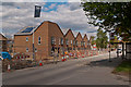
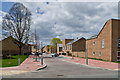
3
Rye Crescent
Newly built housing as part of the regeneration of the Ramsden Estate.
Image: © Ian Capper
Taken: 29 Apr 2013
0.03 miles
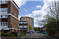
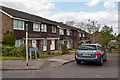
4
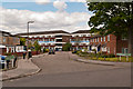
Lamberhurst Close
A cul de sac of 1980s housing off Eldred Drive. In the background is one of the blocks typical of the 1960s development of the Ramsden Estate, Peckham House.
Image: © Ian Capper
Taken: 16 May 2012
0.04 miles
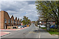
5
Flats, Petten Grove, Orpington, Kent
Just in case you thought that everyone in Orpington lived in palaces. And, although it's Wednesday - it's washday for some of us.
Image: © Dr Neil Clifton
Taken: 26 Apr 2006
0.04 miles
6
Rye Crescent
New houses under development as part of the regeneration of the Ramsden Estate.
Image: © Ian Capper
Taken: 16 May 2012
0.05 miles
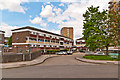
7
Westwell Close
Cul de sac off Rye Crescent, giving access to some of the blocks of flats built in 1968-1970 as part of the development of the Ramsden Estate: Wittersham House on the left, Eastling and Fawkham Houses on the right and Hollingbourne Tower in the background.
Image: © Ian Capper
Taken: 29 Apr 2013
0.06 miles
8
Wichling Close
A cul de sac off Eldred Drive. The photos show two of the types of housing that typify the 1960s development of the Ramsden Estate, three story blocks (here Hougham House) and tower blocks (with Hollingbourne Tower seen here in the background).
Image: © Ian Capper
Taken: 16 May 2012
0.06 miles
9
Pinson Way
Newly built housing as part of the regeneration of the Ramsden Estate.
Image: © Ian Capper
Taken: 29 Apr 2013
0.07 miles
10
Box Tree Walk
A cul de sac of 1960s housing off Eldred Drive.
Image: © Ian Capper
Taken: 16 May 2012
0.07 miles