IMAGES TAKEN NEAR TO
Shaw Road, BROMLEY, BR1 5NN
Introduction
This page details the photographs taken nearby to Shaw Road, BR1 5NN by members of the Geograph project.
The Geograph project started in 2005 with the aim of publishing, organising and preserving representative images for every square kilometre of Great Britain, Ireland and the Isle of Man.

There are currently over 7.5m images from over14,400 individuals and you can help contribute to the project by visiting https://www.geograph.org.uk
Image Map
Images are licensed for reuse under creativecommons.org/licenses/by-sa/2.0
Notes
- Clicking on the map will re-center to the selected point.
- The higher the marker number, the further away the image location is from the centre of the postcode.
Image Listing (31 Images Found)
Images are licensed for reuse under creativecommons.org/licenses/by-sa/2.0
Image
Details
Distance
1
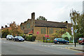
St. Luke's Church, Downham
On Northover.
Image: © Robin Webster
Taken: 30 Oct 2011
0.07 miles
2
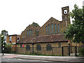
St Luke's church, Downham
St Luke's is a simple brick church built in 1928 during the rapid expansion of London suburbs between Lewisham and Bromley. The architect was Sir Charles Nicholson who also designed several other churches in the area. The building is not listed. It is one of three churches in the Catford and Downham team ministry.
This is the west end, facing the road called Northover. The low "lean-to" style of entrance is sometimes called a Galilee porch.
Image: © Stephen Craven
Taken: 26 Aug 2010
0.07 miles
3
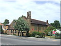
St. Luke's Church, Downham
St. Luke's Church is located in the Downham Estate, a large housing estate developed in the 1920s to ease a housing shortage in London.
Image: © Malc McDonald
Taken: 25 May 2011
0.07 miles
4
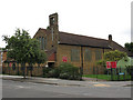
St Luke's church, Downham
St Luke's is a simple brick church built in 1928 during the rapid expansion of London suburbs between Lewisham and Bromley. The architect was Sir Charles Nicholson who also designed several other churches in the area. The building is not listed. It is one of three churches in the Catford and Downham team ministry.
This is the south side, on Shroffold Road.
Image: © Stephen Craven
Taken: 26 Aug 2010
0.08 miles
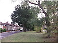
6
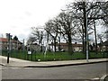
The Northover triangle
A triangle of undeveloped land between Northover (foreground), Shroffold Road and Durham Hill forms a small "village green" with a few mature trees.
Street furniture seen here includes a bus stop, sewer vent pipe and 20mph speed limit signs.
Image: © Stephen Craven
Taken: 26 Aug 2010
0.09 miles
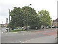
8
Durham Hill
A suburb outside the London postal zones, in BR1.
Image: © Robin Webster
Taken: 30 Oct 2011
0.10 miles
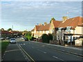
9
Green on Woodbanks Road
This open space and trees are between two roads (both called Woodbanks Road).
The road is part of the Green Chain Walk (long distance path) leading from Grove Park, through the Downham housing estate towards Downham.
Image: © David Anstiss
Taken: 18 Sep 2011
0.12 miles
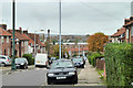
10
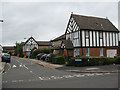
Gittens Close
This small development in an anachronism in two ways. The "mock tudor" half-timbering is obviously out of character with all the other housing in the area, and the houses look relatively new (1980s perhaps) whereas most of the housing in the whole area between Catford and Bromley was developed between the two world wars.
Image: © Stephen Craven
Taken: 26 Aug 2010
0.15 miles