IMAGES TAKEN NEAR TO
Hillcrest Road, NEWHAVEN, BN9 9EZ
Introduction
This page details the photographs taken nearby to Hillcrest Road, BN9 9EZ by members of the Geograph project.
The Geograph project started in 2005 with the aim of publishing, organising and preserving representative images for every square kilometre of Great Britain, Ireland and the Isle of Man.

There are currently over 7.5m images from over14,400 individuals and you can help contribute to the project by visiting https://www.geograph.org.uk
Image Map
Images are licensed for reuse under creativecommons.org/licenses/by-sa/2.0
Notes
- Clicking on the map will re-center to the selected point.
- The higher the marker number, the further away the image location is from the centre of the postcode.
Image Listing (17 Images Found)
Images are licensed for reuse under creativecommons.org/licenses/by-sa/2.0
Image
Details
Distance
1
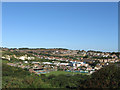
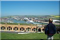
View of Newhaven
Looking inland from Castle Hill. In the foreground is Fort Road the home to Newhaven Town FC beyond to the left is Meeching Quarry now home to an industrial estate whilst to the right are the houses of the town of Newhaven that cling to the hill above the harbour.
Image: © Simon Carey
Taken: 31 Aug 2012
0.10 miles
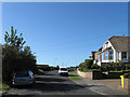
2
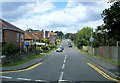
First Avenue, Newhaven
Taken from the junction of Western Road.
Image: © Kevin Gordon
Taken: 20 Jul 2008
0.14 miles
3
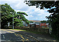
Greys Primary School, Western Road, Newhaven
Image: © Kevin Gordon
Taken: 20 Jul 2008
0.17 miles
4
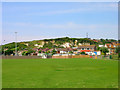
Meeching Quarry
Now containing an industrial estate but was once owned and operated by the Earl of Sheffield and also included ice houses built into the chalk for storage of ice which was imported into Newhaven and moved from the quayside to the quarry via a tramway. The recreation ground in the foreground is another legacy from the Earl of Sheffield and contains the town's cricket and football grounds.
Image: © Simon Carey
Taken: 29 May 2008
0.17 miles
5
Newhaven
Looking across Newhaven Harbour from Newhaven Fort
Image: © Graham Pritchard
Taken: Unknown
0.19 miles
6
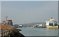
Newhaven
Newhaven Port looking north eastwards with ferry terminal (right) and swing bridge on horizon
Image: © Roz South
Taken: 1 May 2007
0.19 miles
7
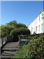
Hill Crest Road
Laid out in the 1920s as the town of Newhaven expanded southward. It follows the contours of the hill the town is built on running south then west from Bayvue Road.
Image: © Simon Carey
Taken: 31 Aug 2012
0.21 miles
8
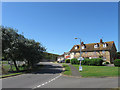
Court Farm Road
Once the road to Meeching Court Farm now an access road for the houses that line the route and a couple of caravan parks. Taken from the junction with Quarry Road.
Image: © Simon Carey
Taken: 26 Aug 2012
0.22 miles
9
Old Coastguard Cottages
Dating from the early 19th century they overlook the harbour and for many years were the only buildings in the vicinity. The town reached the cottages by the early 20th century and had engulfed them during the interwar years. They are located at a right angle off Geneva Road.
Image: © Simon Carey
Taken: 31 Aug 2012
0.22 miles
10
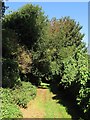
Nun's Walk
Footpath linking Image to Image and a case whereby a local name for a footpath eventually becomes the official one. The footpath skirted lands belonging to the former Convent of the Sacred Heart based in nearby Church Hill.
Image: © Simon Carey
Taken: 31 Aug 2012
0.23 miles