IMAGES TAKEN NEAR TO
The Avenue, LEWES, BN7 3LJ
Introduction
This page details the photographs taken nearby to The Avenue, BN7 3LJ by members of the Geograph project.
The Geograph project started in 2005 with the aim of publishing, organising and preserving representative images for every square kilometre of Great Britain, Ireland and the Isle of Man.

There are currently over 7.5m images from over14,400 individuals and you can help contribute to the project by visiting https://www.geograph.org.uk
Image Map
Images are licensed for reuse under creativecommons.org/licenses/by-sa/2.0
Notes
- Clicking on the map will re-center to the selected point.
- The higher the marker number, the further away the image location is from the centre of the postcode.
Image Listing (131 Images Found)
Images are licensed for reuse under creativecommons.org/licenses/by-sa/2.0
Image
Details
Distance
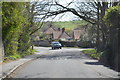
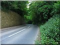
2
Ashcombe Lane, Kingston Near Lewes
The road narrows ahead as part of a traffic calming measure.
Image: © J.Hannan-Briggs
Taken: 12 Apr 2015
0.03 miles
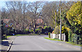
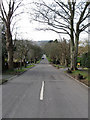
3
Ashcombe Lane, Kingston near Lewes
Heading southwards into the village.
Image: © Simon Carey
Taken: 19 Aug 2018
0.03 miles
4
Ashcombe Lane
A continuation of Wellgreen Lane from the junction with The Street up Kingston Hollow to Nan Kemp's Corner where it becomes Ashcombe Hollow. The main route through the village and a notorious rat run for those wanting to join the A27 by avoiding Lewes.
Image: © Simon Carey
Taken: 8 Feb 2009
0.04 miles
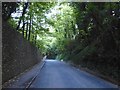
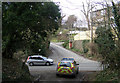
5
Kingston Hollow
Carrying Ashcombe Lane down into the village of Kingston. Viewed from Nan Kemp's Corner.
Image: © Simon Carey
Taken: 26 Jul 2012
0.06 miles
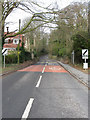
6
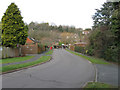
Lockitt Way
Looking back towards the junction with The Avenue whose only traffic is of the four legged variety. The rise in land can be seen clearly beyond.
Image: © Simon Carey
Taken: 8 Feb 2009
0.06 miles
7
The Avenue
The area between The Street and Kingston Ridge has been built up from the 1930s onwards with this road being the main access road for all the small estates.
Image: © Simon Carey
Taken: 8 Feb 2009
0.07 miles
8
Kingston Hollow from Juggs Lane.
Kingston Ridge is the road opposite.
Image: © Kevin Gordon
Taken: 31 Jan 2009
0.10 miles
9
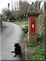
Pillar Box in Kingston Ridge near Lewes
This unusual pillar box is brick built and topped with an over-large flint roof. It is number BN7 578.
Image: © Kevin Gordon
Taken: 31 Jan 2009
0.10 miles
10
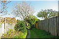
Spring in the back alley, Kingston near Lewes
Not registered as a public way, this route between back gardens is in the newer part of Kingston.
Image: © Robin Webster
Taken: 24 Apr 2010
0.10 miles