IMAGES TAKEN NEAR TO
Court Road, LEWES, BN7 2UF
Introduction
This page details the photographs taken nearby to Court Road, BN7 2UF by members of the Geograph project.
The Geograph project started in 2005 with the aim of publishing, organising and preserving representative images for every square kilometre of Great Britain, Ireland and the Isle of Man.

There are currently over 7.5m images from over14,400 individuals and you can help contribute to the project by visiting https://www.geograph.org.uk
Image Map
Images are licensed for reuse under creativecommons.org/licenses/by-sa/2.0
Notes
- Clicking on the map will re-center to the selected point.
- The higher the marker number, the further away the image location is from the centre of the postcode.
Image Listing (1050 Images Found)
Images are licensed for reuse under creativecommons.org/licenses/by-sa/2.0
Image
Details
Distance
1
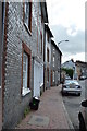
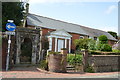
10 - 15, Friar's Walk
All Grade II listed. http://www.britishlistedbuildings.co.uk/en-293088-13-14-15-friar-s-walk-lewes-east-sussex & http://www.britishlistedbuildings.co.uk/en-293087-12-friar-s-walk-lewes-east-sussex & http://www.britishlistedbuildings.co.uk/en-293086-10-and-11-friar-s-walk-lewes-east-sussex
Image: © N Chadwick
Taken: 12 Jul 2015
0.02 miles
2
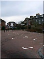
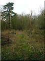
Route of Former Railway
Roughly following the route of the original line from Brighton into the first Lewes Station. All track was removed by the end of the 1960s and the area developed for housing. The backs of the older houses in Friars Walk are to the right.
Image: © Simon Carey
Taken: 4 Feb 2007
0.03 miles
4
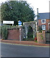
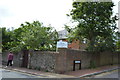
Greyfriars gate Lewes
This is the only surviving part of the Grey Friars Franciscan Friary it was built in 1224 and demolished in 1538, this gate was re-erected here in the middle of the 19th century
Image: © PAUL FARMER
Taken: 23 Nov 2012
0.04 miles
5
Railway Land Nature Reserve
This part was once the grounds of a Victorian house called Leighside an island surrounded by railway tracks which could be reached only by a bridge from Pinwell Road. Today the area is part of a nature reserve that covers the area from the river to the edge of the town.
Image: © Simon Carey
Taken: 4 Feb 2007
0.04 miles
9
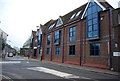
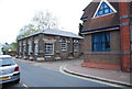
Friends Meeting House
Grade II listed. http://www.britishlistedbuildings.co.uk/en-293109-friends-meeting-house-lewes-east-sussex
Image: © N Chadwick
Taken: 12 Jul 2015
0.04 miles
10
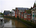
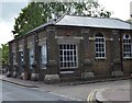
Former warehouses on the River Ouse, Lewes
Looking south from the bridge over the Ouse at Cliffe, these buildings give an indication that the Ouse remained navigable into Lewes and that the river was used to transport goods into town up to the early part of the twentieth century. They have all been converted into other uses now.
Image: © Simon Carey
Taken: 26 Oct 2005
0.04 miles