IMAGES TAKEN NEAR TO
Landport Farm Road, LEWES, BN7 2FP
Introduction
This page details the photographs taken nearby to Landport Farm Road, BN7 2FP by members of the Geograph project.
The Geograph project started in 2005 with the aim of publishing, organising and preserving representative images for every square kilometre of Great Britain, Ireland and the Isle of Man.

There are currently over 7.5m images from over14,400 individuals and you can help contribute to the project by visiting https://www.geograph.org.uk
Image Map
Images are licensed for reuse under creativecommons.org/licenses/by-sa/2.0
Notes
- Clicking on the map will re-center to the selected point.
- The higher the marker number, the further away the image location is from the centre of the postcode.
Image Listing (48 Images Found)
Images are licensed for reuse under creativecommons.org/licenses/by-sa/2.0
Image
Details
Distance
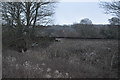
1
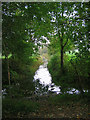
Landport Farm
Viewed from an unmarked path that connects the Landport Estate with the river, a frozen drainage ditch is in the foreground.
Image: © Simon Carey
Taken: 29 Dec 2008
0.06 miles
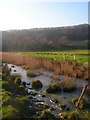
2
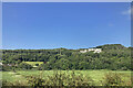
Malling Brooks near Lewes
River Ouse just north of Lewes looking south east from Offham Hill. The appearance of the river and lush grazing marshes make a delightful approach to the town when viewed from a window of the London to Lewes train.
Image: © David Saunders
Taken: 2 Jan 2005
0.11 miles
3
Track to Landport
Connecting the Landport estate on the northern edge of Lewes with the River Ouse. The track appears not be marked as a public footpath though seems to be regularly used by locals. The bridge carries the Lewes-Wivelsfield line over the track.
Image: © Simon Carey
Taken: 29 Dec 2008
0.12 miles
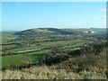
4
View from railway
Looking west, just outside Lewes, towards an old chalk pit.
Roughly a reverse of this view Image
Image: © Stephen Richards
Taken: 7 Jun 2023
0.12 miles
5
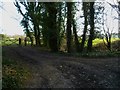
Footpath and byway junction south of Offham
The footpath through the gate to the left goes to the River Ouse. The byway on the right goes to Landport Road.
Image: © Shazz
Taken: 26 Feb 2012
0.14 miles
7
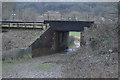
Railway bridge KJE1/674 (probably)
The railway is the Keymer Junction to Lewes link. The number is guessed from the fact that the next bridge in the London direction is 673. It gives farm access to the strip of fields between the railway and the River Ouse.
Image: © Robin Webster
Taken: 27 Oct 2016
0.16 miles
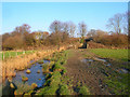
8
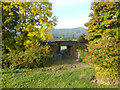
Chalkpit Cut, Lewes
Taken from the track that links Offham with Landport Farm looking east. Chalkpit cut heads east to join the River Ouse. The waterway running parallel to the track is Papermill Cut. As the names suggest these are both artificial waterways.
Image: © Simon Carey
Taken: 26 Oct 2005
0.16 miles
9
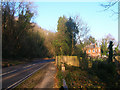
Ousedale House, Offham Road
On the slope next to Offham Road, the A275, opposite the Chalk Pit Inn. Now a bed and breakfast.
Image: © Simon Carey
Taken: 29 Dec 2008
0.16 miles