IMAGES TAKEN NEAR TO
Common Lane, HASSOCKS, BN6 8TJ
Introduction
This page details the photographs taken nearby to Common Lane, BN6 8TJ by members of the Geograph project.
The Geograph project started in 2005 with the aim of publishing, organising and preserving representative images for every square kilometre of Great Britain, Ireland and the Isle of Man.

There are currently over 7.5m images from over14,400 individuals and you can help contribute to the project by visiting https://www.geograph.org.uk
Image Map
Images are licensed for reuse under creativecommons.org/licenses/by-sa/2.0
Notes
- Clicking on the map will re-center to the selected point.
- The higher the marker number, the further away the image location is from the centre of the postcode.
Image Listing (30 Images Found)
Images are licensed for reuse under creativecommons.org/licenses/by-sa/2.0
Image
Details
Distance
1
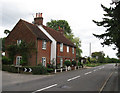
Cottages, North End
On the northern edge of the village of Ditchling beyond them the road becomes Common Lane. Numbered 1 to 3 only the middle cottage has name, Lavender Cottage.
Image: © Simon Carey
Taken: 16 Aug 2009
0.07 miles
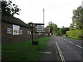
2
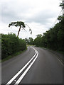
Common Lane
The B2112 as it heads north out of Ditchling towards Wivelsfield Green and Haywards Heath. The road is an old London-Brighton coach road that is still used by the annual bike ride and veterans car rally between the two cities.
Image: © Simon Carey
Taken: 16 Aug 2009
0.07 miles
3
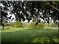
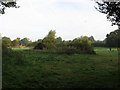
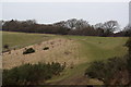
Second Plat
The name of the field according to the 1843 tithe map. The original small field whose boundary outline can just be made out by the darker coloured grass has now enlarged with First Plat, another small field to the south. The name plat suggests the plots were probably former woods.
Image: © Simon Carey
Taken: 19 Aug 2009
0.14 miles
4
Hampers Croft
The name of the field according to the 1843 tithe map.
Image: © Simon Carey
Taken: 19 Aug 2009
0.14 miles
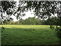
5
First Plat
The name of the field according to the 1843 tithe map. The small plot has been joined with Second Plat to the north to form a large field. The name suggests former use as a small wood.
Image: © Simon Carey
Taken: 19 Aug 2009
0.14 miles
6
The Lain
The name of the field according to the 1843 tithe map. The houses in Dumbrells Court Road can be seen at the bottom of the field.
Image: © Simon Carey
Taken: 19 Aug 2009
0.15 miles
7
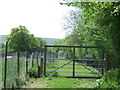
Gate on the footpath, Ditchling
A gate on a footpath leading into the village of Ditchling, in the South Downs National Park. The South Downs ridge is visible in the background.
Image: © Malc McDonald
Taken: 26 May 2013
0.17 miles
8
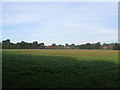
Lower West
The name of the field according to the 1843 tithe map. Court Gardens Farm is to the left whilst the Weald can be seen in the distance.
Image: © Simon Carey
Taken: 19 Aug 2009
0.17 miles
9
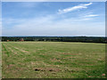
Rural scene near Ditchling
This is the footpath and field to the north west of Ditchling and to the south east of Oldland Mill.
Image: © David Cumberland
Taken: 15 Feb 2009
0.18 miles
10
Turner Dumbrell Workshops
Viewed from North End, the B2112, the former outbuildings of North End Farm have been converted into local craft workshops run by the Turner Dumbrell Trust. See link for some of the tenants http://www.turnerdumbrellworkshops.co.uk/tenants.htm
Image: © Simon Carey
Taken: 19 Aug 2009
0.19 miles