IMAGES TAKEN NEAR TO
Folders Lane East, HASSOCKS, BN6 8SE
Introduction
This page details the photographs taken nearby to Folders Lane East, BN6 8SE by members of the Geograph project.
The Geograph project started in 2005 with the aim of publishing, organising and preserving representative images for every square kilometre of Great Britain, Ireland and the Isle of Man.

There are currently over 7.5m images from over14,400 individuals and you can help contribute to the project by visiting https://www.geograph.org.uk
Image Map
Images are licensed for reuse under creativecommons.org/licenses/by-sa/2.0
Notes
- Clicking on the map will re-center to the selected point.
- The higher the marker number, the further away the image location is from the centre of the postcode.
Image Listing (30 Images Found)
Images are licensed for reuse under creativecommons.org/licenses/by-sa/2.0
Image
Details
Distance
1
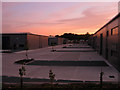
S M Tidy Industrial Estate
Similar view as Image but taken after sunset.
Image: © Simon Carey
Taken: 10 Oct 2009
0.01 miles
2
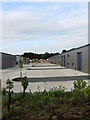
S M Tidy Industrial Estate
Recently erected industrial units awaiting occupants. Viewed from the footpath that runs from Ditchling Common to the Sussex Border Path the units were built on the site of a former brick and tile works which also extracted the clay from the soil here to make its products.
Image: © Simon Carey
Taken: 16 Aug 2009
0.02 miles
3
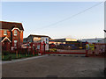
S M Tidy Industrial Estate
There are two industrial estates here built on the site of a former brick and tile works which also extracted the clay it needed from the grounds. The cottage on the left may well originate from the time of the works. The current industrial estate has recently been completed and is awaiting occupants hence the to let sign.
Image: © Simon Carey
Taken: 16 Aug 2009
0.11 miles
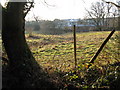
4
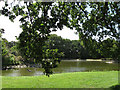
Pond, Long Field
The name of the field according to the 1843 tithe map. Both the pond, the garden and the house are fairly recent constructions. The pond seems to be home to a large number of Canada Geese.
Image: © Simon Carey
Taken: 23 Aug 2009
0.12 miles
5
New Industrial units at the north end of Tidy's Yard
Image: © Dave Spicer
Taken: 6 Feb 2010
0.12 miles
6
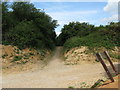
Track at the SE corner of Ditchling Common Country Park
Image: © Dave Spicer
Taken: 20 May 2009
0.14 miles
7
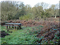
Picnic table, Ditchling Common country park
As the map suggests, there are few tables scattered around this part of the common. Not too inviting a prospect in November, but no doubt pleasant in the summer.
Image: © Robin Webster
Taken: 19 Nov 2010
0.15 miles
8
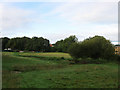
Farther Yard Field West
The name of the field according to the 1843 tithe map. Located next to Ditchling Common Industrial Estate built on the site of a former brick and tile works.
Image: © Simon Carey
Taken: 16 Aug 2009
0.16 miles
9
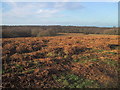
The bracken in Autumn on Ditchling Common.
An image of the autumn bracken on Ditchling Common, East Sussex.
Image: © David Cumberland
Taken: Unknown
0.17 miles
10
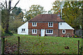
Cottage by bridleway
The bridleway here is a private track serving several houses and in former times Ditchling Potteries.
Image: © Robin Webster
Taken: 19 Nov 2010
0.17 miles